'Trail of Time' in Grand Canyon 10/05/2024
2024년 10월 5일 토 맑음
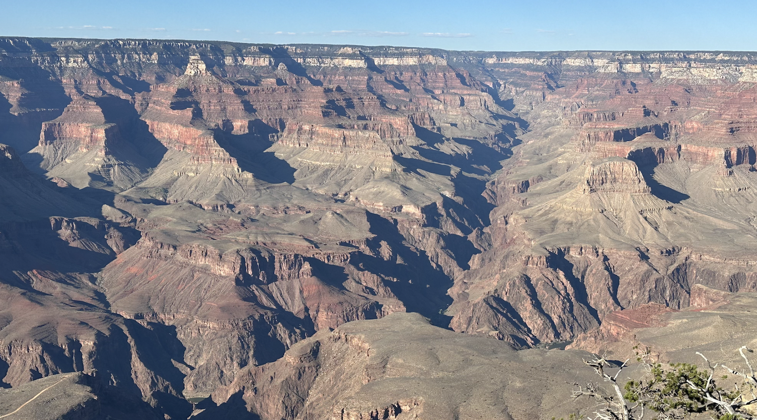
Grand Canyon 으로 향한다. 매년 와서 봐도 새롭게 느껴지는 거대한 지형. 지질학자들의 Mecca 인 Grand Canyon. 이번에는 Yavapai Geology Museum (지질학 박물관)에 전시된 설명을 모두 읽어보고 싶다. 그리고, “ Grand Cayon Trail of Time” 왕복 5.6 마일을 걷고 싶다. Grand Canyon 을 보러 오는 분들을 위해 박물관에 전시된 지형 설명을 모두 사진으로 찍어 올려 보았다.

HW 58,40,15 를 80마일 (128Km/h)로 달려본다. 엄청덥다. 화씨 109도 (섭씨 43도). 올때는 더위를 피하기위해 밤새도록 13시간 동안 달려왔다. 총 거리 1503 miles (2414Km). 이 거리라면, 서울에서 북경까지 육로로 1300 Km이니깐 거의 북경 왕복거리라고 보면된다.

Grand Canyon에 도착해보니 90도 정도로 그렇게 덥지 않았다. 그동안 California는 Indian Summer 로 엄청 더웠는데 Arizona는 예외인 듯했다.
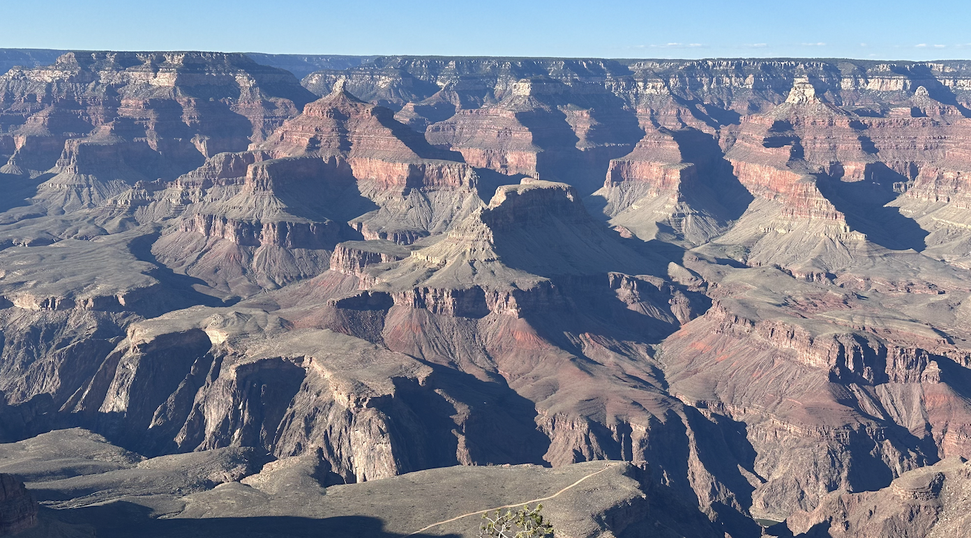
가뭄과 산불에 강하다는 Ponderosa 소나무 숲으로 이루어져 있는 Kaibab 고원을 지나 드디어 South Rim에 도착한다. 눈앞에 전개되는 저 장엄한 Grand Canyon! 숨이 막혀온다. 저 엄청난 계곡이 어쩌면 이렇게도 조용할 수 있을까? 마치 저 밑에 흐르는 Colorado 강물 소리만 들리는 것같다.

와! 저 미약한 Colorado강이 이렇게 엄청난 지형을 만들었다. 보이지 않는 힘이란 바로 이런 것이다. 깊이 1.6km, 폭 16km, 길이 443Km의 Grand Canyon은 지질학의 보고가 아닐수 없다.

형형색색의 지층들이 떡시루처럼 겹겹이 쌓여있는 모습이 몽블랑에서 본 알프스 산맥의 휘어진 습곡과는 많이 달랐다. 저 밑 계곡에서 Rim까지 올라 오는데 지질학 역사로 무려 20억년이 걸린다. 지금 나는 한눈에 20억년의 억겁을 그대로 보고있는 것이다. 여기 말고 다른 어느곳에서 연속되는 지질학적으로 의미가 있는 암석들을 한꺼번에 볼수있을까?

지금 나는 South Rim의 2억 5천만년전의 중생대 트라이아이스기 암석을 밟고, 20억년전의 원생대 계곡 바닥에서는 콜로라도강이 선캄브리아기의 편암을 깍아내고있는 것을 보고있는 셈이다. 위 사진에서 보듯이 측면 협곡이 두드러지는데, 이는 콜로라도 강과 지류가 층을 깎아내어 시간이 지남에 따라 협곡의 넓이가 넓어졌기 때문이다. 하바수 캐년(Havasu Canyon)과 브라이트 엔젤 캐년(Bright Angel Canyon)과 같은 일부 눈에 띄는 측면 협곡은 뚜렷한 지질학적 특징을 보여주고있다.
The Colorado River races 1,400 miles from its headwaters in the Rocky Mountains to its end at the Gulf of California. Twenty percent of its course (277 miles) winds through Grand Canyon. 콜로라도 강은 로키산맥의 원류에서 캘리포니아 만 끝까지 1,400마일이나 뻗어 있다. 코스의 20%(277마일)가 그랜드 캐년을 통과한다.
What Caused the Rise of the Colorado Plateau?
선캄브리아대부터 신생대까지 융기와 침강을 반복하며 얕은 바다와 늪지로 이루어진 곳이었기 때문에 퇴적층이 두껍게 발달했다. 이지대는 신생대 당시 로키 산맥과 함께 3000미터 이상 솟아올라 현재의 콜로라도 고원이 형성된 것이다. 지난 600만 년 동안 콜로라도 강과 그 지류의 침식력에 의해 Grand Canyon 이 형성되었지만, 초기 형성은 콜로라도 고원이 융기된 약 7천만 년 전에 시작되었다. 차등 침식은 Grand Canyon의 독특한 모습을 형성하는 데 중요한 역할을 했다. 침식에 대한 암석층의 다양한 저항은 협곡 전체에 뚜렷한 계단, 절벽, 테라스를 만들었다. 가장 깊고 오래된 암석층은 비슈누 지하 암석으로 약 17억년에서 20억년 전에 형성된 변성암과 화성암의 복잡한 집합체를 구성한다.
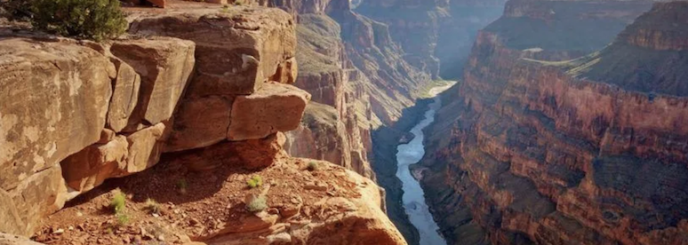
지구의 나이 48억년. 그 일부인 20억년을 Grand Canyon 에서 느낄수 있었다. 1700만년전 태평양 판이 북아메리카 판을 들어 올리면서 Colorado 고원이 융기했다. 바로 이 시점이 Grand Canyon 의 시작이다. 마치 타임머신을 타고 과거로 돌아가는 기분이다. Grand Canyon 곳곳의 퇴적암에는 선캄브리아기에서 신생대까지, 고대 동·식물들의 화석이 풍부하게 남아 있다. 일반적으로 지반이 융기하면 그 과정에서 암석이 부서지고 변형되는데 특이하게도 콜로라도 고원은 그대로 땅을 들어 올린 것처럼 변형이 거의 없었다. 퇴적층 줄무늬가 기울어지거나 끊겨 있지 않고 수평을 이루고 있는 이유다. 지질학적 역사를 시간순으로 볼 수 있는 교과서인 것이다.

This is a relief map of the Grand Canyon. The elevation is represented using shading. The lightest color represents the highest elevation while the darkest color represents the lowest elevation.
그런데 Grand Canyon 북쪽에서 흘러내리는 Glen Canyon 계곡물은 콜로라도 강이 아닌 리오그란데 강의 지류였다. 현재는 Glen Canyon 에서 강이 흘러와 서쪽으로 90도 꺾여 Grand Canyon으로 흘러들지만, 과거에는 Grand Canyon 동부를 남북으로 흐르는 강이었던 것이다. 이후 로키 산맥이 더 융기하며 남쪽에서 막힌 강줄기가 거대한 호수를 이루었고, 별도로 Colorado 고원 서쪽으로 흘러가던 강줄기(현재의 Meed lake 부근)는 고원을 점차 침식해들어가며 계곡 자체가 동진, 보다 깊은 계곡을 만들고 마침내 고원 동부의 강과 연결되어 버렸다.

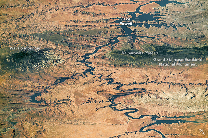
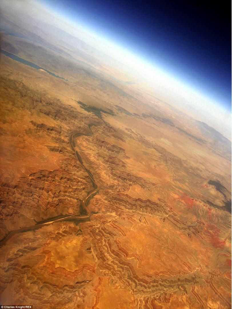
View of the Grand Canyon from Space
그 결과 Colorado 강은 카리브 해가 아닌 태평양을 향해 흐르게 되고, 빠른 유속과 풍부한 유량으로 차별침식이 강화되어 현재의 Grand Canyon이 만들어진 것이다. Grand Canyon을 자세히 보면 이런 차별침식의 흔적이 나타나는데 남쪽 벽은 거의 깎아지른 절벽이지만 북쪽 사면은 약간 넓은 모양이다. 콜로라도 고원 전체가 수평으로 솟아오른 게 아니라 융기 과정에서 다소 삐딱하게 솟아오른 탓에 북쪽 사면이 더 넓게 깎여나간 것이다.
-

-

다음은 NASA에서 제공한 Grand Canyon 사진


Yavapai Geology Museum

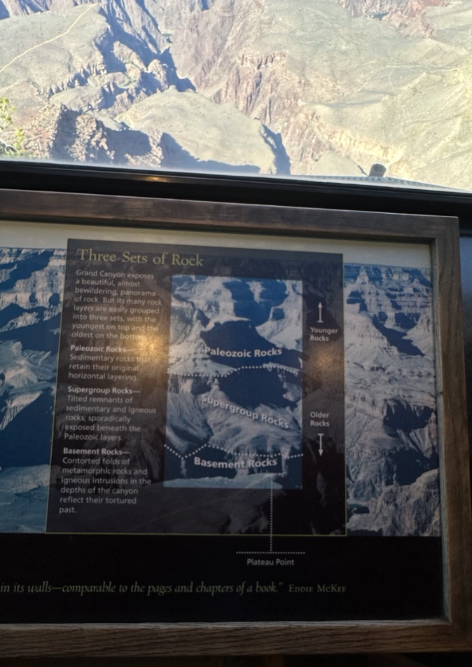
Three Sets of Rock
Grand Canyon exposes a beautiful, almost bewildering, panorama of rocks. But its many rock layers are easily grouped into three sets, with the youngest on top and the oldest on the bottom.
Paleozoic Rocks - Sedimentary rocks that retain their original horizontal layering.
Supergroup Rocks - Tilted remnants of sedimentary and igneous rocks, sporadically exposed beneath the Paleozoic layers.
Basement Rocks - Contorted folds of metamorphic rocks and igneous intrusions in the depths of the canyon reflect their tortured past.
세 세트의 암석
그랜드 캐년은 아름답고 거의 어리둥절할 정도의 암석 파노라마를 보여준다. 그러나 그 많은 암석층은 세 세트로 쉽게 그룹화되며, 가장 어린 것이 맨 위에 있고 가장 오래된 것이 맨 아래에 있다.
고생대 암석 - 원래의 수평층을 유지하고 있는 퇴적암이다.
슈퍼그룹 암석 - 고생대 지층 아래에 산발적으로 노출된 퇴적암과 화성암의 기울어진 잔해이다.
지하 암석 - 변성암의 뒤틀린 주름과 협곡 깊이의 화성암 관입은 고통스러운 과거를 반영해준다.

The Power of a River
The Colorado River, like liquid sandpaper, uses the sediments it carries to carve its canyons. Driven by weather and climate, the Colorado river deepens its course. The river gathers rain and snowmelt from the Rocky Mountains. Swollen by springtime runoff and summer storms. The Colorado’s muddy waters churn. Silt, sand, and cobbles grind against each other and against bedrock channels. Its water carries the abrasive load downstream, ultimately surrendering it to the Gulf of California. Empowered by time - over 5 million years worth - the river does what gravity demands.
강의 힘
콜로라도 강은 액체 사포처럼 운반된 퇴적물을 사용하여 협곡을 깎는다. 날씨와 기후에 따라 콜로라도 강은 수로를 깊게 한다. 강은 로키산맥에서 녹은 비와 눈을 모은다. 봄철 유출수와 여름 폭풍으로 인해 강물이 부어올랐다. 콜로라도의 진흙탕 물이 휘젓는다. 미사, 모래, 자갈은 서로 마찰을 일으키고 기반암 수로와 마찰을 일으킨다. 그 물은 연마재를 하류로 운반하여 궁극적으로 캘리포니아만으로 넘겨준다. 500만년 이상의 시간에 힘입어 강은 중력이 요구하는 일을 하는 것이다.
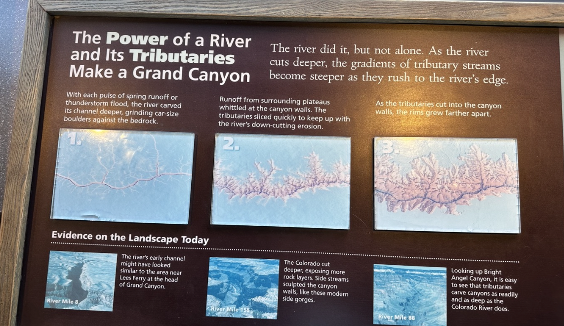
The Power of a River and its Tributaries make a Grand Canyon./ The river did it, but not alone. As the river cuts deeper, the gradients of tributary streams become steeper as they rush to the river's edge.
강의 힘과 그 지류가 Grand Canyon을 만든다./ 강이 해냈지만 혼자가 아니었다. 강의 깊이가 깊어짐에 따라 지류의 경사는 강의 가장자리로 돌진하면서 더욱 가파르게 된다.
With each pulse of spring runoff or thunderstorm flood, the river carved its channel deeper, grinding car-size boulders against the bedrock. / Runoff from surrounding plateaus whittled at the canyon walls. The tributaries slice quickly to keep up with the river's down-cutting erosion. / As the tributaries cut into the canyon walls, the rims grew farther apart.
봄철 유출수나 뇌우 홍수가 발생할 때마다 강물은 수로를 더 깊게 파고 기반암에 자동차 크기의 바위가 깎아냈다. / 주변 고원에서 흘러나온 빗물이 협곡 벽을 깎아 내렸다. 강의 하류 침식을 따라잡기 위해 지류는 빠르게 갈라진다. / 지류가 협곡 벽을 깎으면서 가장자리가 더 멀어졌다.
Evidence on the Landscape Today - The river's early channel might have looks similar to the area near Lees Ferry at the head of Grand Canyon. / The Colorado cut deeper, exposing more rock layers. Side streams sculpted the canyon walls, like these modern side gorges. / Looking up Bright Angel Canyon, it is easy to see that tributaries carve canyons as readily and as deep as the Colorado River does.
아마도 Grand Canyon 의 머리 부분에 있는 Lees Ferry 근처 지역과 비슷하게 생겼을 것이다. / 콜로라도강은 더 깊이 파고들어 더 많은 암석층을 노출시켰다. 측면 계곡물은 현재 볼수있는 측면 협곡처럼 협곡 벽을 조각했다. / Bright Angel Canyon을 올려다 보면 지류가 콜로라도 강만큼 쉽고 깊게 협곡을 깎아내는 것을 쉽게 알 수 있다.

Too Thick to Drink, Too Thin to Plow - Spanish missionary Fray Francisco Garces, while exploring the region in 1776, named the river Rio Colorado - Colorado River- inspired by its reddish color. / Before Glen Canyon Dam was built the Colorado River was free-flowing. It carried 86 million tons of sediment through Grand Canyon every year. / The clear-green water that flows through Grand Canyon today is sediment-starved. Choked back by Glen Canyon Dam the sediments settle to the bottom of Lake Powell. / A muddy Colorado River echoes its former character, carrying sediment delivered by flooding tributaries downstream of Glen Canyon Dam.
마시기에는 너무 진하고, Plow 하기에는 너무 얇다 - 스페인 선교사 Fray Francisco Garces는 1776년 이 지역을 탐험하면서 붉은 색에서 영감을 받아 강을 리오 콜로라도(콜로라도 강)라고 명명했다. / Glen Canyon댐이 건설되기 전에는 콜로라도 강이 자유롭게 흐르고 있었다. 매년 Grand Canyon을 통해 8,600만 톤의 퇴적물이 운반되었다. / 오늘날 Grand Canyon을 흐르는 맑은 녹색 물에는 퇴적물이 부족하다. Glen Canyon댐에 의해 막힌 퇴적물은 Lake Powell 바닥에 침전된다. / 진흙 투성이의 콜로라도 강은 Glen Canyon 댐 하류의 범람한 지류에 의해 운반된 퇴적물을 운반하면서 예전의 성격을 반영한다.

The Yavapai point Museum presents one of the grandest views on Earth. But this is not just any view of Grand Canyon. In the 1920s some of the most eminent scientific minds gathered in the national park to select the best representative view of Gand Canyon geology. They chose this site and conceived of this building to showcase one of the world's great wonders.
Yavapai point Museum은 지구상에서 가장 웅장한 전망 중 하나다. 그러나 이것은 단지 Grand Canyon의 풍경이 아니다. 1920년대에 가장 저명한 과학자들이 Grand Canyon 지질학을 가장 잘 대표하는 전망을 선택하기 위해 국립공원에 모였다. 그들은 이 장소를 선택했고 세계의 위대한 불가사의 중 하나를 전시하기 위해 이 건물을 구상했다.

"This chasm has been studied and restudied by generations of geologists. For as grandly simple as this place appears… we continue to be presented with new facts, new interpretations, and new lessons." - Earle Spamer
"이 거대한 틈은 여러 세대의 지질학자들에 의해 연구되고 재연구되었다. 이곳이 겉보기에는 매우 단순하기 때문에… 우리에게는 계속해서 새로운 사실, 새로운 해석, 새로운 교훈이 제시되었다." - Earle Spamer
STANDING on the SHOULDERS of GIANTS / Geologists today know more about Grand Canyon than geologists did in the 1800s. But the discoveries of these early pioneers laid the foundation of knowledge that present-day geologists build on. Every new geologist stands on the shoulders of those who came before. The early geology giants honored here contributed greatly to our understanding of the canyon and to the workings of the world.
거인의 어깨에 서서 / 오늘날 지질학자들은 1800년대 지질학자들보다 Grand Canyon 에 대해 더 많이 알고 있다. 그러나 이들 초기 개척자들의 발견은 오늘날의 지질학자들이 쌓아온 지식의 기초를 놓았다. 모든 새로운 지질학자들은 이전에 온 사람들의 어깨 위에 서 있다. 이곳에서 영예를 얻은 초기 지질학적 거인들은 협곡과 대자연의 작용에 대한 우리의 이해에 크게 기여했다.
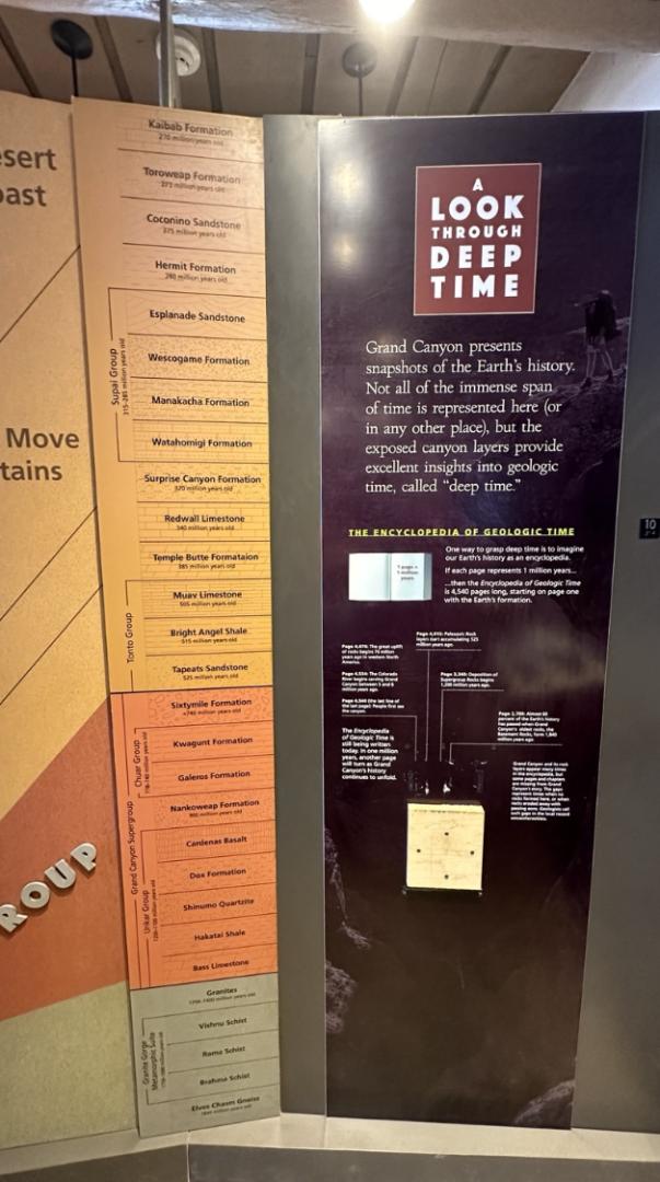
A LOOK THROUGH DEEP TIME - Grand Canyon presents snapshots of the Earth's history. Not all of the immense span of time is represented here ( or in any other place), but the exposed canyon layers provide excellent insights into geologic time, called " deep time." /
깊은 시간을 통해 살펴보기 - Grand Canyon은 지구의 역사에 대한 스냅샷을 제공한다. 여기에(또는 다른 장소에서) 엄청난 시간이 모두 표현된 것은 아니지만, 노출된 협곡 지층은 "깊은 시간"이라고 불리는 지질학적 시간에 대한 뛰어난 통찰력을 보여준다.
The Encyclopedia of Geologic Time - One way to grasp deep time is to imagine our Earth's history as an encyclopedia. If each page represents 1 million years… then the Encyclopedia of Geologic Time is 4,540 pages long, starting on page one with the Earth's formation. / Grand Canyon and its rock layers appear many times in the encyclopedia, but some pages and chapters are missing from grand Canyon's tory. The gaps represent times when no rocks eroded away with passing eons. Geologists call such gaps in the local record unconformities.
지질시대 백과사전 - 깊은 시간을 파악하는 한 가지 방법은 지구의 역사를 백과사전으로 상상하는 것이다. 각 페이지가 100만 년을 나타낸다면… 지질시대백과사전의 길이는 4,540페이지이며, 첫 페이지에서 지구의 형성으로 시작된다. / Grand Canyon 과 그 암석층은 백과사전에 여러 번 등장하지만, Grand Canyon 의 이야기에는 일부 페이지와 장이 누락되어 있다. 그 틈은 영겁의 시간이 지나도 암석이 침식되지 않았던 시대를 나타낸다. 지질학자들은 지역 기록의 이러한 틈을 부정합면이라고 부른다.
Page 2,700: Almost 60 percent of the Earth's history has passed when grand Canyon's oldest rocks, the Basement Rocks, form 1,840 million years ago. / Page 3,340: Deposition of Supergroup Rocks begins 1,200 million years ago. / Page 4,015: Paleozoic Rock layers start accumulating 525 million years ago. / Page 4,470: The great uplift of rocks begins 70 million years ago in western North America. / Page 4,534: The Colorado River begins carving Grand Canyon between 5 and 6 million years ago. / Page 4,540 (the last line of the last page): People first see the Canyon.
Page 2,700쪽: Grand Canyon에서 가장 오래된 암석인 지하 암석이 18억 4천만년 전에 형성되었을 때 지구 역사의 거의 60%가 지났다. / Page 3,340쪽: 누층군 암석의 퇴적은 12억년 전에 시작되었다./ Page 4,015쪽: 고생대 암석층은 5억 2500만년 전부터 쌓이기 시작했다. / Page 4,470쪽: 암석이 크게 융기되는 현상은 7천만년 전 북미 서부에서 시작되었다. / Page 4,534쪽: 콜로라도 강은 500만년에서 600만년 전 사이에 Grand Canyon을 조각하기 시작했다. / Page 4,540쪽 (마지막 페이지 마지막 줄) : 인간들이 처음으로 Grand Canyon을 보기 시작했다.
The Encyclopedia of Geologic Time is still being written today. In one million years, another page will turn as Grand Canyon's history continues to unfold.
지질시대백과사전은 오늘날에도 여전히 집필되고 있다. 백만년 후에는 그랜드 캐년의 역사가 계속해서 펼쳐지면서 또 다른 페이지가 펼쳐질 것이다.
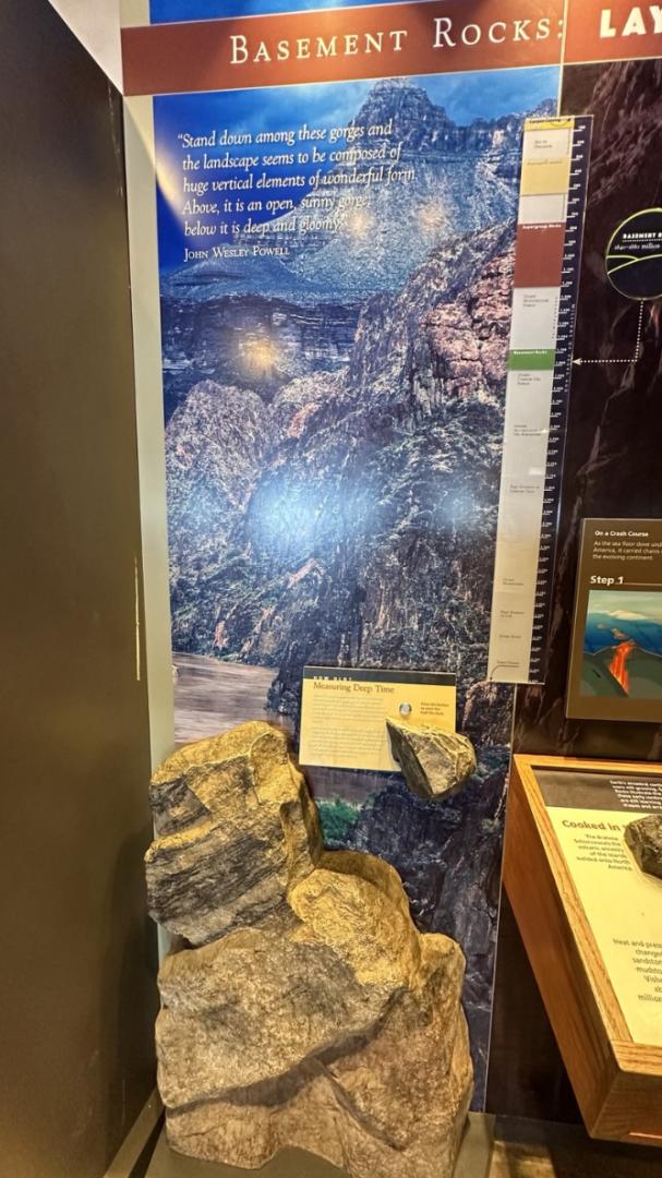
Stand down among these gorges and the landscape seems to be composed of huge vertical elements of wonderful form. Above, it is an open, sunny gorge, below it is deep and gloomy - John Wesley Powell
이 협곡 사이에 서면 풍경은 놀라운 형태의 거대한 수직 요소로 구성된 것처럼 보인다. 위에는 햇볕이 잘 드는 탁 트인 협곡이 있고 아래에는 깊고 우울한 협곡이 있다. - John Wesley Powell

Cooked in the Basement - Earth's ancestral continents, 1,700 million years ago, were still growing. Grand Canyon's Basement Rocks illustrate the processes by which these early continents evolved. Geologists are still learning about the continents' shapes and arrangements. / The collisions injected magma into existing rocks, where it cooled to form granite and pegmatite. / The most ancient rock in Grand Canyon is the metamorphic Elves Chasm Gneiss. It is a fragment of continental crust 1,840 million years old. / Miles below the mountain peaks, heat and pressure were so intense that the original structure of the rocks was fundamentally altered or metamorphosed.
Cooked in the Basement - 17억년 전 지구의 조상 대륙은 여전히 성장하고 있었다. Grand Canyon의 지하 암석은 이러한 초기 대륙이 진화한 과정을 보여준다. 지질학자들은 여전히 대륙의 모양과 배열에 대해 연구하고있다. / 충돌로 인해 마그마가 기존 암석에 주입되어 냉각되어 화강암과 페그마타이트가 형성되었다. / Grand Canyon에서 가장 오래된 암석은 변성 엘프 캐즘 편마암(Elves Chasm Gneiss)이다. 이는 18억 4천만년 전의 대륙 지각의 단편이다. / 산봉우리 아래 몇 마일 아래에서는 열과 압력이 너무 강해서 암석의 원래 구조가 근본적으로 변경되거나 변형되었다.
What Makes a Continent? - To geologists continents are thick stable platforms that extend well beyond the coast. Their submerged edges rise far above the deep ocean floor. Grand Canyon's Basement Rocks are part of the North American continent's very foundation.
무엇이 대륙을 만드는가? - 지질학자들에게 대륙은 해안 너머까지 뻗어 있는 두껍고 안정적인 플랫폼이다. 그들의 물에 잠긴 가장자리는 깊은 해저보다 훨씬 높다. Grand Canyon 의 지하 암석은 북미 대륙의 기초 중 일부이다.

LAYING THE FOUNDATION - Grand Canyon's story began 1,840 million years ago as volcanic island chains collided with a young, growing North American continent. The collisions were violent, crumpling rock layers into mountains and changing their minerals. Rising magma from inside Earth welded the contorted mass to the edge of the continent, forming the Basement Rocks. The rocks cooled and erosion attacked the mountain peaks. After millions of years, the core of the mountains was exposed as a hard rock plain under a thin mantle of mineral soil. By 1,400 million years ago Grand Canyon's foundation was laid.
기초 놓기 - Grand Canyon 의 이야기는 18억 4천만년 전 화산섬 체인이 젊고 성장하는 북미 대륙과 충돌하면서 시작되었다. 충돌은 격렬했고, 암석층이 구겨져 산이 되고 광물이 변했다. 지구 내부에서 솟아오르는 마그마가 뒤틀린 덩어리를 대륙 가장자리에 용접하여 지하 암석을 형성했다. 암석은 식었고 침식은 산봉우리를 깎아냈다. 수백만 년이 지난 후, 산의 중심부는 얇은 광물 토양 맨틀 아래 단단한 암석 평원으로 드러냈다. 이렇게 14억년 전에 Grand Canyon의 기초가 놓여졌다.
Step 1 On a Crash Course - As the sea floor dove under the edge of North America, it carried chains of volcanic islands toward the evolving continent. / Step 2 Collision - Unable to follow the plunge of the denser sea floor, the volcanic islands collided with the continental edge. Tremendous hear and pressure welded them together, forming the Basement Rocks. / Step 3 Forging a continent - Erosion by rain and snow reduced the mountains to a smooth plain. The erosion continues until hard rocks, forged miles below the surface, lay exposed.
1단계 충돌 코스에서 - 해저가 북아메리카 가장자리 아래로 잠수하면서 생성되는 대륙을 향해 일련의 화산섬을 운반했다. / 2단계 충돌 - 밀도가 높아진 해저의 급락을 따라갈 수 없어 화산섬들이 대륙 가장자리와 충돌했다. 엄청난 소리와 압력이 그것들을 녹여 지하 암석을 형성했다. / 3단계 대륙 형성 - 비와 눈에 의한 침식으로 인해 산들이 평탄한 평원으로 변했다. 침식은 표면 아래 수 마일 아래로 형성된 단단한 암석이 노출될 때까지 계속되었다.

Supergroup Rocks: " Surface appearances are only that, topography grows, shrinks, compresses, spreads, disintegrates, and disappears, every scene is temporary, and is composed of fragments from other scenes." - John McPhee
Supergroup Rocks: "표면의 모습은 지형이 커지고, 줄어들고, 압축되고, 퍼지고, 분해되고 사라지는 것일 뿐이며, 모든 장면은 일시적이며 다른 장면의 조각으로 구성되어 있다." - 존 맥피

Angled Layers above the Foundation. / One Layer at aTime.. Then all Tilted Together. / Supergroup Rocks, like those in this model, were once as orderly as a tack of pancakes, with the oldest at the bottom and the youngest on top. But after tilting, faulting, and erosion, the Supergroup stack was not so orderly. To untangle the jumble, geologists use the principles of stratigraphy, placing geologic events in sequence. Rock layers are first deposited horizontally, with the oldest rocks laid on the bottom. Any tilting or cuts across the layers from faults or volcanic intrusions happens later.
기반지층 위의 각진 지층들. / 한 번에 한 겹.. 그런 다음 모두 함께 기울어진다. / Supergroup Rocks는 한때 팬케이크 처럼 질서정연했다. 가장 오래된 팬케이크가 맨 아래에 있고 가장 어린 팬케이크가 맨 위에 있었다. 그러나 기울어짐, 단층 및 침식 이후에 Supergroup stack은 그다지 질서정연하지 않았다. 혼란스러운 상황을 해결하기 위해 지질학자들은 층서학의 원리를 사용하여 지질 사건을 순서대로 배치했다. 암석층은 먼저 수평으로 퇴적되며, 가장 오래된 암석이 바닥에 쌓인다. 단층이나 화산 침입으로 인해 지층이 기울어지거나 절단되는 일은 나중에 발생한다.
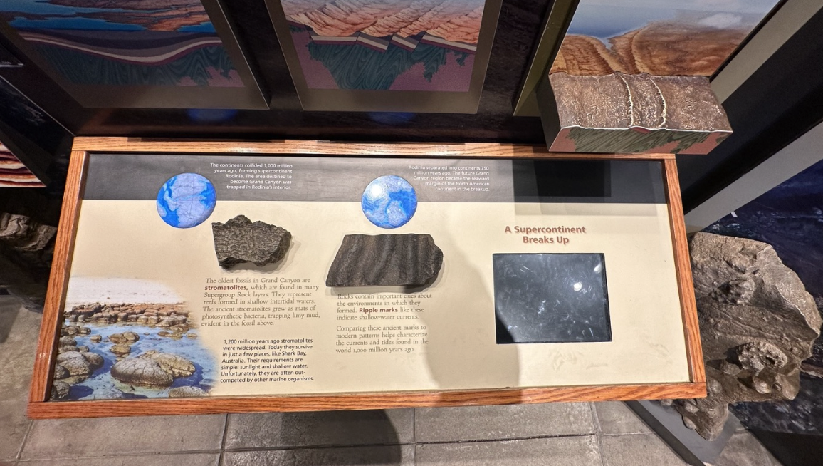
The continents collides 1,000 million years ago, forming supercontinent Rodinia. The area destined to become Grand Canyon was trapped in Rodinia's interior. / Rodinia separated into continents 750 million years ago. The future Grand Canyon region became the seaward margin of the North American continent in the breakup. / The oldest fossils in Grand Canyon are stromatolites, which are found in many Supergroup Rock layers. They represent reefs formed in shallow intertidal waters. The ancient stromatolites grew as mats of photosynthetic bacteria, trapping limy mud, evident in the fossil above. / Rocks contain important clues about the environments in which they formed. Ripple marks like these indicate shallow-water currents. Comparing these ancient marks to modern patterns helps characterize the currents and tides found in the world 1,000 millions years ago. /1,200 million years ago stromatolites were widespread. Today they survive in just a few places, like Shark Bay, Australia. Their requirements are simple: sunlight and shallow water. Unfortunately, they are often out-competed by other marine organisms.
10억년 전 대륙이 충돌하여 초대륙 Rodinia 가 형성되었다. Grand Canyon 이 될 지역은 Rodinia 내부에 갇혀 있었다. / Rodinia는 7억 5천만년 전에 대륙으로 분리되었다. 미래의 Grand Canyon지역은 해체되면서 북미 대륙의 바다 쪽 가장자리가 되었다./ Grand Canyon 에서 가장 오래된 화석은 Stromatolites로, 많은 Supergroup Rock 층에서 발견된다. 그들은 얕은 조간대에서 형성된 암초를 나타낸다. 고대 Stromatolites는 광합성 박테리아의 매트로 성장하여 위의 화석에서 명백하게 나타나는 석회 진흙을 가두었다. / 암석은 자신이 형성되었던 환경에 대한 중요한 단서를 담고 있다. 이와 같은 잔물결 표시는 얕은 물의 흐름을 나타낸다. 이러한 고대 표시를 현대 패턴과 비교하면 1억년 전 세계에서 발견된 해류와 조수의 특징을 파악하는 데 도움이 된다. /12억년 전에는 Stromatolites가 널리 퍼져 있었다. 오늘날 그들은 호주의 Shark Bay와 같은 몇몇 장소에서만 생존하고 있다. 요구 사항은 간단하다. 햇빛과 얕은 물이다. 불행하게도 그들은 종종 다른 해양 생물들에 의해 경쟁에서 압도된다.
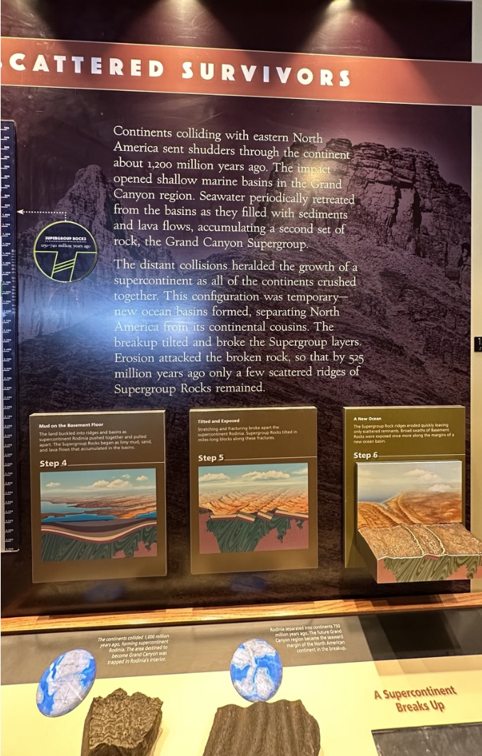
Cattered Survivals - Continents colliding with eastern North America sent shudders through the continent about 1,200 million years ago. The impact opened shallow marine basins in the Grand Canyon region. Seawater periodically retreated from the basins as they filled with sediments and lava flows, accumulating a second set of rock, the Grand Canyon Supergroup. The distant collisions heralded the growth of a supercontinent as all of the continents crushed together. This configuration was temporary-new ocean basins formed, separating North America from its continental cousins. The breakup tilted and broke the Supergroup layers. Erosion attacked the broken rock, so that by 525 million years ago only a few scattered ridges of Supergroup Rocks remained.
약 12억년 전 대륙들이 북아메리카 동부와 충돌하면서 진동이 대륙 전체에 전해졌다. 그 충격으로 그랜드 캐년 지역의 얕은 해양 분지가 열렸다. 해수는 퇴적물과 용암류로 채워지면서 분지에서 주기적으로 후퇴하여 두 번째 암석 세트인 그랜드 캐년 슈퍼그룹(Grand Canyon Supergroup)을 축적했다. 먼 곳에서 일어난 충돌은 모든 대륙이 뭉개지면서 초대륙이 성장할 것을 예고했다. 이 구성은 일시적으로 새로운 해양 분지가 형성되어 북미와 같은 부류의 대륙을 분리하는 것이다. 이 분리는 기울어져 Supergroup 레이어를 깨뜨렸다. 침식은 부서진 암석을 공격하여 5억 2,500만 년 전에는 Supergroup Rocks의 흩어져 있는 능선 몇 개만 남았있다.
Step 4 : Mud on the Basement Floor - The land buckled into ridges and basins as supercontinent Rodinia pushed together and pulled apart. The Supergroup Rocks began as limy mud, sand, and lava flows that accumulated in the basins.
4단계: 지하 바닥의 진흙 - 초대륙 로디니아(Rodinia)가 서로 밀렸다가 갈라지면서 땅이 능선과 분지로 휘어졌다. Supergroup Rocks는 분지에 쌓인 석회질 진흙, 모래, 용암 흐름으로 시작되었다.
Step 5 : Tilted and Exposed. - Stretching and fracturing broke apart the supercontinent Rodinia. Supergroup Rocks tilted in miles-long blocks along these fractures.
5단계: 기울어지고 노출된다. - 팽창과 균열로 인해 초대륙 로디니아가 분리되었다. Supergroup Rocks는 이러한 균열을 따라 수 마일 길이의 블록으로 기울어졌다.
Step 6: A New Ocean - The Supergroup Rock ridges eroded quickly leaving only scattered remnants. Broad swaths of Basement Rocks were exposed once more along the margins of a new ocean basin.
6단계: 새로운 바다 - Supergroup Rock 능선은 빠르게 침식되어 흩어진 잔해만 남았다. 새로운 해양 분지의 가장자리를 따라 넓은 범위의 지하 암석이 다시 한 번 노출되었다.

Paleozoic Rocks - " In one place is seen sand of ancient dunes, in another the border of an early-sea, or … the unmistakable evidence of life - plants and animals preserved to make a reality of the living, moving past" - Eddie Mckee, 1931
고생대 암석 - "한 곳에서는 고대 모래 언덕의 모래가 보이고, 다른 곳에서는 초기 바다의 경계가 보인다. 또는… 생명의 명백한 증거, 살아 움직이는 과거를 현실로 만들기 위해 보존된 식물과 동물" - Eddie Mckee , 1931
-

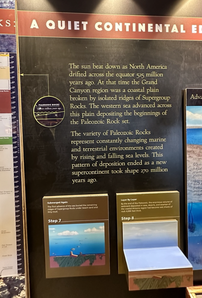
A Quiet Continental - The sun beat down as North America drifted across the equator 525 million years ago. At that time the Grand Canyon region was a coastal plain broken by isolated ridges of Supergroup Rocks. The western sea advanced across this plain depositing the beginnings of the Paleozoic Rock set. The variety of Paleozoic Rocks represent constantly changing marine and terrestrial environments created by rising and falling sea levels. This pattern of deposition ended as a. ew supercontinent took shape 270 million years ago.
5억 2천 5백만년 전 북아메리카가 적도를 넘어 표류하면서 태양이 내리쬐었다. 그 당시 그랜드 캐년 지역은 Supergroup Rocks의 고립된 능선으로 인해 부서진 해안 평야였다. 서해가 이 평원을 가로질러 전진하여 고생대 암석층의 시작점이 퇴적되었다. 다양한 고생대 암석은 해수면 상승 및 하강으로 인해 끊임없이 변화하는 해양 및 육상 환경을 나타냈다. 이 퇴적 패턴은 다음과 같이 끝났다. 새로운 초대륙은 2억 7천만년 전에 형성되었다.
Step 7: Submerged Again - The first advance of the sea buried the remaining ridges of Supergroup Rocks under beach sand and limy mud.
7단계: 다시 물속에 잠김 - 바다의 첫 번째 전진으로 인해 Supergroup Rocks의 남은 능선이 해변 모래와 석회 진흙 아래에 묻혔다.
Step 8: Layer By Layer - By the end of the Paleozoic, the enormous volume of sediment deposited in seas, deserts, and swamps of the coastal Arizona region had become vast sheets of rock 4,000 feet thick.
8단계: 층별 층 - 고생대 말기에 애리조나 해안 지역의 바다, 사막, 늪에 퇴적된 엄청난 양의 퇴적물은 두께가 4,000피트에 달하는 거대한 암석층이 되었다.
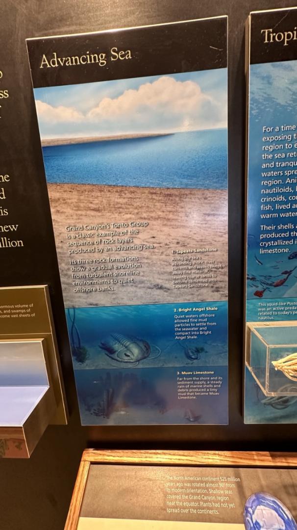
Advancing Sea - Grand Canyon's Tonto Group is a classic example of the sequence of rock layers produced by an advancing sea. Its three rock formations show a gradual evolution from turbulent shoreline environments to quiet offshore banks. / 1. Tapeats Sandstone - Along the sea's advancing shore, river currents and waves swept away fine material, leaving coarse sands to become cemented into Tapeats Sandstone. 2. Bright Angel Shale - Quiet waters offshore allowed fine mud particles to settle from the seawater and compact into Bright Angel Shale. 3. Muav Limestone - Far from the shore and its sediment supply, a steady rain of marine shells and debris produced a limy mud that became Muav Limestone.
전진하는 바다 - 그랜드 캐년의 톤토 그룹(Tonto Group)은 전진하는 바다에 의해 생성된 일련의 암석층의 전형적인 예다. 세 개의 암석층은 격동의 해안선 환경에서 조용한 연안 제방으로 점진적인 진화를 보여준다. / 1. 타피츠 사암(Tapeats Sandstone) - 전진하는 바다 해안을 따라 강물의 흐름과 파도가 미세한 물질을 휩쓸고 거친 모래를 남겨서 타핏 사암(Taeatats Sandstone)으로 굳어지게 되었다. 2. 브라이트 엔젤 셰일(Bright Angel Shale) - 앞바다의 조용한 바다에서는 미세한 진흙 입자가 바닷물에서 침전되어 브라이트 엔젤 셰일이 압축될 수 있었다. 3. 무아브 석회암(Muav Limestone) - 해안과 퇴적물 공급원에서 멀리 떨어진 곳에서 해양 조개와 잔해의 꾸준한 비로 인해 무아브 석회암이 된 석회 진흙이 생성되었다.
The North American continent 525 million years ago was rotated almost 90 degrees from its modern orientation. Shallow seas covered the Grand Canyon region near the equator. Plants had not yet spread over the continents.
5억 2,500만 년 전 북미 대륙은 현재의 방향에서 거의 90도 회전했다. 적도 부근의 그랜드 캐년 지역은 얕은 바다로 덮여 있었다. 식물은 아직 대륙으로 퍼지지 않았다.
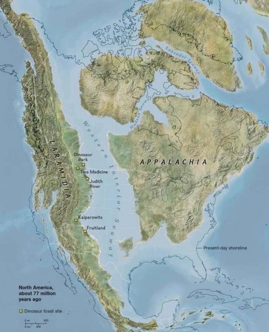
North America 77 million years ago.

North America 93 Million Years Ago

Tropical Seas - For a time the sea retreated, exposing the Grand Canyon region to erosion. When the sea returned, warm and tranquil tropical waters spread across the region. Animals, including nautiloids, brachiopods, crinoids, corals, and armored fish, lived and fed in the warm waters. Their shells and skeletons produced the limy mud that crystallized into layers of limestone. /4. Temple Butte Formation - The sea's first advance was timid. East of here, its deposits are confined to channels cut by the tides on the surface of Muav Limestone. / This squid-like Posterioceras was an active predator closely related to today's pearly nautilus. / Again the sea retreated and returned, depositing Redwall Limestone - part of a belt of limestone that extends from abundant sea life thrives in warm, shallow waters.
열대 바다 - 한동안 바다가 물러나면서 그랜드 캐니언 지역이 침식에 노출되었다. 바다가 돌아오자 따뜻하고 고요한 열대 바다가 지역 전체에 퍼졌다. 노틸로이드, 완족류, 바다나리, 산호, 장갑 물고기를 포함한 동물들은 따뜻한 물에서 살고 먹이를 먹었다. 그들의 껍질과 뼈대는 석회암 층으로 결정화된 석회 진흙을 생성했다. /4. Temple Butte Formation - 바다의 첫 번째 진격은 소심했다. 여기 동쪽에는 무아브 석회암 표면의 조수에 의해 잘려진 수로에만 퇴적물이 있었다. / 오징어처럼 생긴 이 포스테리오케라스는 오늘날의 진주빛 노틸러스와 밀접한 관련이 있는 활동적인 포식자였다. / 다시 바다는 물러났다가 되돌아오면서 레드월 석회암(Redwall Limestone)을 퇴적시켰다. 풍부한 해양 생물로부터 확장된 석회암 벨트의 일부는 따뜻하고 얕은 물에서 번성했다.

Rivers Move Mountains - Dragonflies attained huge sizes during the Paleozoic. Eastern North America crumpled up against the growing supercontinent Pangea, forming high mountains. Streams and rivers, charged with sediments eroded from these new mountains, spread across the coastal plains of the Grand Canyon region.
강이 산을 움직임 - 잠자리는 고생대 동안 거대한 크기를 얻었다. 북아메리카 동부는 성장하는 초대륙 판게아에 맞서 구겨져 높은 산을 형성했다. 이 새로운 산에서 침식된 퇴적물로 가득 찬 시냇물과 강은 그랜드 캐년 지역의 해안 평야를 가로질러 퍼졌다.
6. Suprise Canyon Formation and Supai Group - Ribbons of Surprise Canyon formation contain abundant fossils from rivers and estuaries. Most of the red layers in the canyon walls are part of the Supai Group. These rock layers represent many different coastal environments with an abundance of red-stained mud and sand in the east, with more beds of marine limestones farther west.
6. 서프라이즈 캐년 형성 및 수파이 그룹 - 서프라이즈 캐년 형성의 리본에는 강과 하구에서 발견된 풍부한 화석이 포함되어 있다. 협곡 벽의 붉은 층 대부분은 수파이 그룹(Supai Group)의 일부이다. 이 암석층은 동쪽에는 붉은색으로 얼룩진 진흙과 모래가 풍부하고 서쪽에는 더 많은 해양 석회암층이 있는 다양한 해안 환경을 나타낸다.
7. Hermit Formation - A drying environment with sand dunes and lush streamside oases deposited the Hermit Formation. Fine-grained sand and mud preserved abundant fern fossils and track marks in the streamsides of this broad coastal plain.
7. 은둔층(Hermit Formation) - 사구와 무성한 강변 오아시스가 있는 건조한 환경이 은둔층을 퇴적시켰다. 이 넓은 해안 평야의 하천변에는 미세한 모래와 진흙이 풍부한 양치식물 화석과 발자국을 보존하고 있다.

Desert Coast
Winds dried as they blew across the supercontinent Pangea, arriving as desert blasts in the Grand Canyon region. Huge sand dunes drifted over this desert plain as it slowly sank, allowing the western sea to advance across extensive salt flats. 바람은 초대륙 판게아를 가로질러 불면서 말랐고, 그랜드 캐년 지역에 갑작스런 사막화가 시작되었다. 이 사막 평원은 천천히 가라앉으면서 거대한 사구가 표류했고, 이로 인해 서해는 광대한 염전을 가로질러 전진했다.
사막해변
8. Coconino Sandstone - Fed by beach sand to the north, winds pushed sand grains toward the central Arizona region. Today sloping crossbeds in Coconino Sandstone display the internal structure of shifting dunes.
8. 코코니노 사암(Coconino Sandstone) - 해변 모래가 북쪽으로 흘러 바람이 모래 알갱이를 애리조나 중부 지역으로 밀어낸다. 오늘날 코코니노 사암(Coconino Sandstone)의 경사진 교차층은 움직이는 모래언덕의 내부 구조를 보여준다.
9. Toroweap and Kaibab Formations - After a short sea advance, represented by the Toroweap Formation, the sea inundated the northwest Arizona region, depositing the Kaibab Formation. The sandy limestone that tops Grand Canyon began as limy debris, shells, and sand beneath shallow marine waters raked by tropical storms.
9. Toroweap 층과 Kaibab 층 - Toroweap 층으로 대표되는 짧은 바다 전진 후, 바다는 애리조나 북서부 지역을 침수시켜 Kaibab 층을 퇴적시켰다. 그랜드 캐년 꼭대기의 모래 석회암은 열대성 폭풍에 의해 긁힌 얕은 바닷물 아래의 석회 잔해, 조개 및 모래로 시작되었다.

Life on Land - On the coastal plains of the Grand Canyon region, rivers supplied moisture for ample growth of club mosses and ferns in a swampy environment. Later, as the climate grew drier, primitive conifers spread and insects, amphibians, and early reptiles flourished.
육상 생활 - 그랜드 캐년 지역의 해안 평야에서는 강물이 수분을 공급하여 늪지대 환경에서 클럽 이끼와 양치류가 충분히 성장할 수 있었다. 이후 기후가 더욱 건조해지면서 원시 침엽수가 퍼지고 곤충, 양서류, 초기 파충류가 번성하게 되었다.
Traces in the Sand - The desert dunes environment represented in the Coconino Sandstone was harsh, but it was not lifeless. Tracks of reptiles, scorpions, and other animals are preserved in these sand-colored rocks.
모래 속의 흔적 - 코코니노 사암으로 표현된 사막 사구 환경은 혹독했지만 생명이 없는 것은 아니었다. 파충류, 전갈 및 기타 동물의 발자국이 모래색 암석에 보존되어 있다.
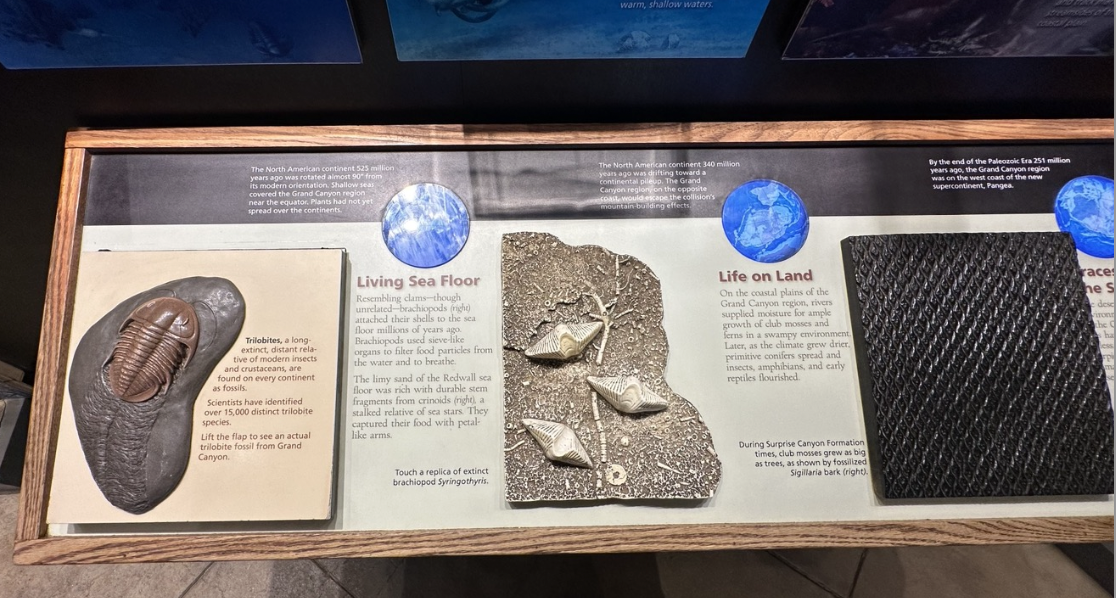
Trilobites - a long-extinct, distant relative of modern insects and crustaceans, are found on every continent as fossils. Scientists have identified over 15,000 distinct trilobite species.
삼엽충 - 현대 곤충과 갑각류의 먼 친척인 삼엽충은 모든 대륙에서 화석으로 발견된다. 과학자들은 15,000종 이상의 서로 다른 삼엽충 종을 확인했다.
Living Sea Floor - Resembling clams - though unrelated-brachiopods attached their shells to the sea floor millions of years ago. Brachiopods used sieve-like organs to filter food particles from the water and to breathe. The limy sand of the Redwall sea floor was rich with durable stem fragments from crinoids, a stalked relative of sea stars. They captured their food with petal-like arms.
살아있는 해저 - 조개와 유사하지만 관련 없는 완족류는 수백만 년 전에 껍질을 해저에 부착했다. 완족류는 체와 같은 기관을 사용하여 물에서 음식물 입자를 걸러내고 호흡했다. Redwall 해저의 석회질 모래에는 불가사리의 줄기가 있는 친척인 바다나리의 튼튼한 줄기 조각이 풍부했다. 그들은 꽃잎 같은 팔로 먹이를 잡았다.
Life on Land - On the coastal plains of the Grand Canyon region, rivers supplied moisture for ample growth of club mosses and ferns in a swampy environment. Later, as the climate grew drier, primitive conifers spread and insects, amphibians, and early reptiles flourished. / During Surprise Canyon Formation times, club mosses grew as big as trees, as shown by fossilized Sigillaria bark.
육상 생활 - 그랜드 캐년 지역의 해안 평야에서는 강물이 수분을 공급하여 늪지대 환경에서 클럽 이끼와 양치류가 충분히 성장할 수 있었다. 이후 기후가 더욱 건조해지면서 원시 침엽수가 퍼지고 곤충, 양서류, 초기 파충류가 번성하게 되었다. / 서프라이즈 캐년 형성 기간 동안, 화석화된 시길라리아 껍질에서 알 수 있듯이 곤봉이끼는 나무만큼 크게 자랐다.

A Plateau Rises - The supercontinent Pangea was breaking up 245 million years ago. During the age of dinosaurs, North America headed northwest, colliding with volcanic island chains and adding them to its western coast. These collisions caused mountain building, and before the dinosaurs became extinct, the Rocky Mountains were already rising. The Colorado Plateau-future home of the Grand Canyon-also rose. Unlike the crumbled mountains around it, the plateau was elevated with only minor distortions. This uniquely level uplift set the stage for spectacular erosion on the Colorado Plateau.
초대륙 판게아는 2억 4500만년 전에 해체되었다. 공룡 시대에 북아메리카는 북서쪽으로 향하면서 화산섬들과 충돌하여 서쪽 해안에 추가되었다. 이러한 충돌로 인해 산이 형성되었고, 공룡이 멸종되기 전에 로키산맥은 이미 융기하고 있었다. 콜로라도 고원(장래 그랜드 캐니언의 본거지)도 상승했다. 주변의 무너진 산들과 달리 고원은 약간의 왜곡만 있을 뿐 융기되어 있었다. 이 독특한 수준의 융기는 콜로라도 고원의 극적인 침식을 위한 무대를 마련했다.
Step 9: Entombed - Rock layers visible in Grand Canyon today were once buried under thousands of feet of debris as mountains to the south and west shed eroded sediments across the northern Arizona Region.
9단계: 매장됨 - 오늘날 그랜드 캐니언에서 볼 수 있는 암석층은 한때 남쪽과 서쪽의 산이 북부 애리조나 지역 전역에 걸쳐 퇴적물을 침식하면서 수천 피트의 잔해 아래 묻혀 있었다.
Step 10: Rising Toward Fame - The nearly level uplift of the Colorado Plateau is geologically exceptional. The plateau rose thousands of feet with almost no violent folds or breaks.
10단계: 예외적인 융기 - 거의 수평에 가까운 콜로라도 고원의 융기는 지질학적으로 예외적이다. 이 고원은 심하게 접히거나 부서지는 일 없이 수천 피트 솟아올랐다.
Step 11: Starting To Look Familiar - As the land rose, erosion removed the higher, younger rock layers fist, sculpting the landscape into forms similar to today's
11단계: 익숙해지기 시작 - 땅이 솟아오르면서 침식으로 인해 더 높고 젊은 암석층이 제거되어 풍경이 오늘날과 유사한 형태로 조각되었다.
Triggered by repeated collisions with island chains, widespread uplift 70 million years ago signaled the end of shallow seas in western North America. Erosion began stripping rock away as the land rose above sea level.
섬들의 열도와의 반복적인 충돌로 촉발된 7천만년 전의 광범위한 융기는 북아메리카 서부의 얕은 바다가 끝났다는 신호였다. 땅이 해수면 위로 올라감에 따라 침식으로 인해 암석이 벗겨지기 시작했다.
The emerging Atlantic Ocean split Pangea 120 million years ago, and North America began a slow journey northwest out of the tropics. Volcanic island chains in its path were assimilated into a growing western coast.
새로 형성된 대서양은 1억 2천만년 전에 판게아를 갈라놓았고, 북아메리카는 열대 지방을 벗어나 북서쪽으로 느린 여행을 시작했다. 그 경로에 있는 화산섬 체인은 성장하는 서부 해안에 융화되었다.
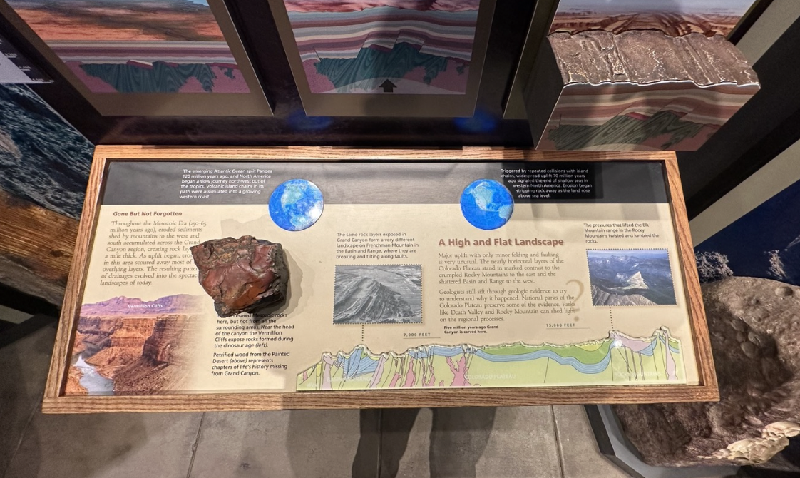
Gone But Not Forgotten - Throughout the Mesozoic Era (250-65 million years ago), eroded sediments shed by mountains to the west and south accumulated across the Grand Canyon region, creating rock lay
사라지지만 잊혀지지 않음 - 중생대(2억 5천만~6천 5백만 년 전) 동안 서쪽과 남쪽의 산에서 흘린 침식된 퇴적물이 그랜드 캐년 지역 전체에 축적되어 암석층을 형성했다.
A High and Flat Landscape - Major uplift with only minor folding and faulting is very unusual. the nearly horizontal layers of the Colorado Plateau stand in marked contrast to the crumpled Rocky Mountains to the cast and the shattered Basin and Range to the west. Geologists still sift through geologic evidence to try to understand why it happened. National parks of the Colorado Plateau preserve some of the evidence. Parks like Death Vally and Rocky Mountain can shed light on the regional processes.
높고 평평한 지형 - 약간의 접힘과 단층만 있는 대규모 융기 현상은 매우 드물다. 거의 수평에 가까운 콜로라도 고원 지층은 캐스트의 구겨진 로키 산맥, 서쪽의 부서진 분지 및 산맥과 뚜렷한 대조를 이룬다. 지질학자들은 왜 그런 일이 일어났는지 이해하기 위해 여전히 지질학적 증거를 면밀히 조사하고 있다. 콜로라도 고원의 국립공원에는 일부 증거가 보존되어 있다. Death Vally 및 Rocky Mountain과 같은 공원은 지역적 과정을 밝힐 수 있다.

Five Million Years and Still Carving - Today the still sweeps sediments downstream to its delta. There heat and pressure are already fusing the sediments into new rock layers. The cycles of erosion and deposition continue. What will the next million years bring? As the canyon walls erode what will future landscapes look like? Only time will tell. / Where Did It All Go? The Colorado River's waters end in the Gulf of California. Sediments settle in the stilled gulf waters, building the river's delta, blanketing the sea floor with muddy ooze, and nourishing ecosystems on land and in sea.
500만년의 세월과 스틸 조각 - 오늘날 스틸은 퇴적물을 삼각주 하류까지 휩쓸고 있다. 열과 압력이 이미 퇴적물을 새로운 암석층으로 융합시키고 있다. 침식과 퇴적의 순환이 계속된다. 다음 백만년에는 어떤 일이 일어날까? 협곡 벽이 침식되면서 미래의 풍경은 어떤 모습일까? 오직 시간만이 말해줄 것이다. / 다 어디로 갔나? 콜로라도 강의 물은 캘리포니아 만에서 끝난다. 퇴적물은 잔잔한 만 해역에 정착하여 강의 삼각주를 형성하고 해저를 진흙탕으로 덮으며 육지와 바다의 생태계에 영양을 공급한다.
The Modern Colorado - Human-made dams are temporary obstacles to the Colorado River. Trapped sediments will fill the reservoirs in mere centuries.
현대 콜로라도 - 인간이 만든 댐은 콜로라도 강의 일시적인 장애물이다. 갇힌 퇴적물은 단 몇 세기 안에 저수지를 채울 것이다.
Volcanoes Dam the River - During the last million years, lava flows dammed the Colorado River in western Grand Canyon many times. Remnants of ancient flows cling to canyon walls. Some ancient lava dams collapsed catastrophically, unleashing monumental floods. Lava could flow again in Grand Canyon. It is still an active volcanic field.
화산이 강을 댐으로 - 지난 백만년 동안 용암류가 그랜드 캐년 서부의 콜로라도 강을 여러 번 댐으로 막았다. 고대 흐름의 잔재가 협곡 벽에 달라붙어 있다. 일부 고대 용암 댐은 재앙적으로 붕괴되어 엄청난 홍수를 일으켰다. 그랜드 캐니언에서는 용암이 다시 흐를 수 있다. 아직도 활동 중인 화산지대이다.
The Force of Melting Glaciers - Glaciers never touched Grand Canyon during the ice age, but the climate here was cooler and wetter. Meltwater from Rocky Mountain glaciers send huge pulses of abrasive glacial sediments downstream, dramatically increasing the flow and cutting power of the Colorado River.
빙하가 녹는 힘 - 빙하기 동안 빙하는 그랜드 캐년에 닿은 적이 없었지만 이곳의 기후는 더 시원하고 습했다. 로키산맥 빙하의 녹은 물이 거대한 마모성 빙하 퇴적물을 하류로 보내 콜로라도 강의 흐름과 절단력을 극적으로 증가시켰다.
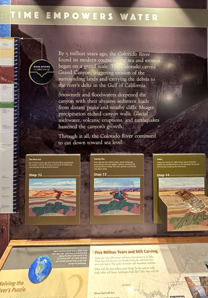
TIME EMPOWERS WATER
By 5 million years ago, the Colorado River found its modern course to the sea and erosion began on a grand scale. The Colorado carved Grand Canyon, triggering erosion of the surrounding lands and carrying the debris to the river's delta in the Gulf of California. Snowmelt and floodwaters deepened the canyon with their abrasive sediment loads from distant peaks and nearby cliffs. Meager precipitation etched canyon walls. Glacial meltwater, volcanic eruptions, and earthquakes hastened the canyon's growth. Through it all, the Colorado River continued to cut down toward sea level.
시간이 물에 힘을 실어준다.
500만년 전, 콜로라도 강은 바다로 향하는 현대적인 경로를 찾았고 대규모 침식이 시작되었다. 콜로라도는 그랜드 캐년을 깎아 주변 땅의 침식을 촉발하고 잔해를 캘리포니아만의 강의 삼각주로 운반했다. 눈이 녹고 홍수로 인해 멀리 떨어진 봉우리와 인근 절벽에서 쌓인 마모성 퇴적물로 인해 협곡이 깊어졌다. 적은 양의 강수량이 협곡 벽을 에칭했다. 빙하가 녹은 물, 화산 폭발, 지진으로 인해 협곡의 성장이 가속화되었다. 이 모든 과정을 통해 콜로라도 강은 계속해서 해수면을 향해 깎아 나갔다.
Step 12: The First Cut - By 5 million years ago the Colorado River established its modern course, flowing to the Gulf of California and actively eroding Grand Canyon.
12단계: 첫 번째 절단 - 500만년 전에 콜로라도 강은 캘리포니아 만으로 흘러가며 그랜드 캐년을 적극적으로 침식하는 현대적인 경로를 만들었다.
Step 13: Trial by Fire - Over the last few million years, active volcanoes poured lava into the western canyon, ponding the Colorado River briefly. The river quickly scoured the lava dams away.
13단계: 불의 시험 - 지난 수백만 년 동안 활화산이 서쪽 협곡에 용암을 쏟아부어 콜로라도 강에 잠시 고이게 했다. 강은 빠르게 용암 댐을 쓸어버렸다.
Step 14: Today - Today the results of 1,840 million years of Earth's history lie exposed before us, but geologic forces are still actively sculpting this landscape.
14단계: 오늘 - 오늘날 18억 4천만 년의 지구 역사의 결과가 우리 앞에 드러났지만, 지질학적 힘은 여전히 활발하게 이 풍경을 조각하고 있다.

" Running water is a puny thing compared to solid rock. Without geologic time, neither sedimentary rocks nor canyons could exist. Deep time gives water dominion over rock…" - J.J. Powell
" 흐르는 물은 단단한 암석에 비하면 하찮은 것이다. 지질학적 시간이 없다면 퇴적암도 협곡도 존재할 수 없다. 깊은 시간은 물이 암석을 지배하게 한다…" - J.J. 파월
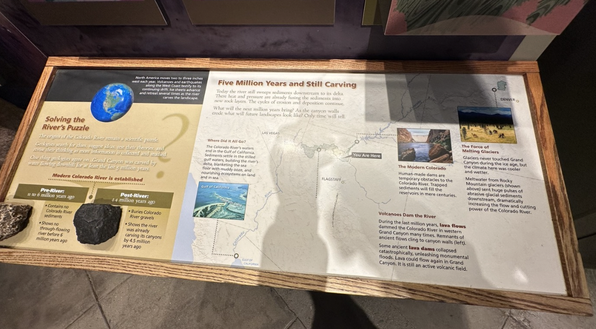
North America moves two to three inches west each year. Volcanoes and earthquakes along the West Coast testify to its continuing drift. Ice sheets advance and retreat several times as the river carves the landscape.
북미는 매년 서쪽으로 2~3인치 이동한다. 서해안의 화산과 지진은 계속되는 지각이동을 입증한다. 강이 풍경을 조각하면서 빙상이 여러 번 전진하고 후퇴했다.
Solving the River's Puzzle. - The origins of the Colorado River remain a scientific puzzle. Geologists search for clues, suggest ideas, test their theories, and revise their thinking as more information is collected and studies. One thing geologists agree on… Grand Canyon was carved by water flowing downhill for at least the last 5 million years. / Pre-River: 11 to 6 million years ago. Contains no Colorado River sediments. Shows no through-flowing river before 6 million years ago. / Post-River: 4.4 million years ago. Buries Colorado River gravels. Shows the river was already carving its canyons by 4.5 million years ago.
강의 퍼즐을 해결 - 콜로라도 강의 기원은 여전히 과학적인 수수께끼로 남아 있다. 지질학자들은 더 많은 정보가 수집되고 연구됨에 따라 단서를 찾고, 아이디어를 제안하고, 이론을 테스트하고, 생각을 수정한다. 지질학자들이 동의하는 한 가지는… 그랜드 캐년은 적어도 지난 500만 년 동안 아래로 흐르는 물에 의해 깎여졌다는 것이다. / 강 이전 : 1100만~600만년 전. 콜로라도 강 퇴적물이 포함되어 있지 않다. 600만년 전에는 흐르는 강이 없었음을 보여준다. / 강 이후: 440만년 전. 콜로라도 강 자갈이 묻혀있다. 강이 이미 450만 년 전에 협곡을 조각하고 있었음을 보여준다.

A LOOK TO THE FUTURE - While the Grand Canyon has been developing over millions of years, people have been part of the story during the last thousands of years. Yet, our actions will help shape what Grand Canyon becomes in the future. Over the last century, temperatures have been rising in the region. Scientists expect this increase to continue through this century. / What effects will climate change have? Even though science suggests that the Earth should be in a cooling trend, scientific evidence also shows that human activities and our lifestyle are steadily increasing the Earth's temperature.
미래에 대한 전망 - 그랜드 캐니언은 수백만 년에 걸쳐 발전해 왔지만 지난 수천 년 동안 사람들은 그 이야기의 일부였다. 하지만 우리의 행동은 미래에 Grand Canyon이 어떤 모습으로 변할지를 결정하는 데 도움이 될 것이다. 지난 세기 동안 이 지역의 기온은 상승해 왔다. 과학자들은 이러한 증가가 금세기 내내 계속될 것으로 예상한다. / 기후변화는 어떤 영향을 미칠까? 과학은 지구가 냉각 추세에 있어야 한다고 제안하지만, 과학적 증거는 인간 활동과 생활 방식이 지구의 온도를 꾸준히 증가시키고 있음을 보여준다.
Rising temperatures causes habitat change. Plants and animals will have to adjust to milder winters and longer summers. Some may adapt, but some may not.기온이 상승하면 서식지 변화가 발생한다. 식물과 동물은 더 온화한 겨울과 더 긴 여름에 적응해야 한다. 일부는 적응할 수 있지만 일부는 그렇지 않을 수도 있다.
Water will become a more precious resource in a warming world. Scientists predict alternating flood and drought to become the norm in Grand Canyon. How will this affect habitats, erosion rates, seeps, springs and the Colorado River?
점점 더워지는 세상에서 물은 더욱 소중한 자원이 될 것이다. 과학자들은 홍수와 가뭄이 교차하는 현상이 그랜드 캐년의 표준이 될 것이라고 예측한다. 이것이 서식지, 침식률, 누출, 샘, 콜로라도 강에 어떤 영향을 미칠까?
-


Debris Flows: Flash Floods Move the Landscape - Experienced hikers know flash floods occur any time of the year, but are most common during summer thunderstorms. Storm runoff plunges into the canyon, incorporating soil, sand, rock, and vegetation into a thick slurry called a debris flow. More soil and rock than water, debris flows tumble car-sized boulders toward the Colorado River.
잔해 흐름: 돌발 홍수가 풍경을 움직인다. - 경험이 풍부한 등산객들은 돌발 홍수가 일년 중 언제든지 발생한다는 것을 알고 있지만 여름 뇌우 중에 가장 흔하다. 폭풍우 유출수는 협곡으로 흘러 들어가 토양, 모래, 암석 및 식물을 토석류라고 불리는 두꺼운 슬러리로 통합한다. 물보다 더 많은 흙과 암석, 잔해가 콜로라도 강을 향해 자동차 크기의 바위처럼 큰덩어리로 흘러간다.
Before December 1966 . Eroded boulder fans at the mouth of Crystal Creek from past flash floods and debris flows created a mild-mannered Crystal Rapid on the Colorado River.
1966년 12월 이전. 과거 돌발 홍수와 잔해류로 인해 크리스탈 크릭(Crystal Creek) 입구에 침식된 바위 팬이 콜로라도 강에 온화한 크리스탈 래피드(Crystal Rapid)를 만들었다.

Ice Breaker: The Power of Freezing Water - Winter storms blanket the canyon with snow. As temperatures rise, melt water trickles into cracks and crevices. On cold nights the water expands as it freezes, prying the rocks apart. On the rims, these nightly attacks go on for months, as long as the water and winter last.
Rock is no match for the force that growing ice crystals generate. As freezing water expands it exerts up to nie tons of pressure per square inch (1,265 kg/cm^2) - enough to burst this pipe or fracture rocks.
아이스 브레이커: 얼어붙는 물의 힘 - 겨울 폭풍이 협곡을 눈으로 덮는다. 온도가 상승하면 녹은 물이 균열과 틈으로 흘러 들어간다. 추운 밤에는 물이 얼면서 팽창하여 바위를 쪼개게 된다. 림에서는 물과 겨울이 지속되는 한 이러한 야간 공격이 몇 달 동안 계속된다.
Rock은 성장하는 얼음 결정이 생성하는 힘에 상대가 되지 않는다. 어는 물이 팽창하면서 평방 인치당 최대 1톤(1,265kg/cm^2)의 압력을 가한다. 이는 이 파이프를 터뜨리거나 암석을 깨뜨릴 만큼 충분하다.
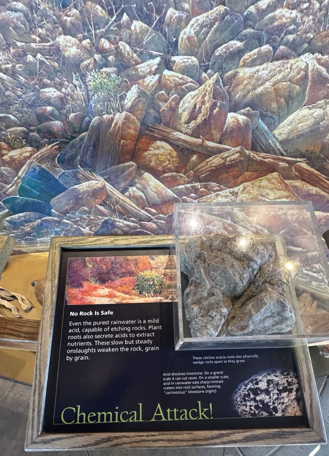
Chemical Attack! No Rock is Safe - Even the purest rainwater is a mild acid, capable of etching rocks. Plant roots also secrete acids to extract nutrients. These slow but steady onslaughts weaken the rock, grain by grain. /These catclaw acacia roots also physically wedge rocks apart as they grow. / Acid dissolves limestone. On a grand scale it can cut caves. On a smaller scale, acid in rainwater eats sharp-rimmed craters into rock surfaces, forming "carnivorous" limestone.
화학적 공격! 어떤 암석도 안전하지 않다. - 가장 순수한 빗물이라도 약산성이므로 암석을 부식시킬 수 있다. 식물의 뿌리는 또한 영양분을 추출하기 위해 산을 분비한다. 이러한 느리지만 꾸준한 공격은 바위를 한알 한알 약화시킨다. /이 Catclaw 아카시아 뿌리는 자라면서 암석을 물리적으로 쐐기로 분리한다. / 산은 석회석을 녹인다. 대규모로 동굴을 자를 수 있다. 더 작은 규모에서는 빗물 속의 산이 날카로운 테두리의 분화구를 바위 표면으로 만들어 먹어치워 "육식성" 석회암을 형성한다.

Collapse : The Way the Canyon Crumbles - The layered rocks of Grand Canyon include hard resistant layers and soft crumbly layers. Softer layers erode faster, undercutting the harder layers above them. The hard layers become unstable overhangs that eventually collapse. / Erosion - resistant Redwall Limestone stands as a bold rock layer throughout Grand Canyon /Strong, interlocking microscopic crystals in Redwall Limestone make the rock massive and erosion resistant. / Muav Limestone contains sand and clay, a weaker combination than the Redwall's crystals. Groundwaters wash these impurities away, causing the Muav to crumble.
붕괴: 협곡이 무너지는 방식 - 그랜드 캐니언의 층상 암석은 단단하고 부서지기 어려운 층과 부서지기 쉬운 층으로 구성되어 있다. 다. 부드러운 층은 더 빨리 침식되어 그 위에 있는 단단한 층을 약화시킨다. 단단한 층은 결국 붕괴되는 불안정한 돌출부가 된다. / 침식에 강한 Redwall 석회암은 그랜드 캐년 전체에 걸쳐 굵은 암석층으로 서 있다. / 강한 Redwall 석회암의 미세 결정이 서로 맞물려 있어 암석이 거대하고 침식에 강하다. / Muav 석회암에는 Redwall의 결정보다 약한 조합인 모래와 점토가 포함되어 있다. 지하수는 이러한 불순물을 씻어내며 Muav를 무너지게 만든다.

" All that we are concerned with is turning your attention to the real things outside." John C. Merriam, 1925. Founder of the Yavapai Point Trailside Museum and President of the Carnegie Institution.
"우리가 관심을 갖는 것은 외부의 실제 사물에 관심을 돌리는 것뿐입니다." John C. Merriam, 1925년. Yavapai Point Trailside Museum 설립자이자 Carnegie Institute 회장.
The Yavapai Point Museum presents one of the grandest views on Earth. But this is not just any view of Grand Canyon. In the 1920s some of the most eminent scientific minds gathered in the national park to select the best representative view of Grand Canyon geology. They chose this site and conceived of this building to showcase one of the world's greatest wonders.
야바파이 포인트 박물관(Yavapai Point Museum)은 지구상에서 가장 웅장한 전망을 제공한다. 그러나 이것은 단지 그랜드 캐년의 풍경이 아니다. 1920년대에 가장 저명한 과학자들이 그랜드 캐년 지질학을 가장 잘 대표하는 전망을 선택하기 위해 국립공원에 모였다. 그들은 세계 최대의 불가사의 중 하나를 전시하기 위해 이 장소를 선택했고 이 건물을 구상했다.
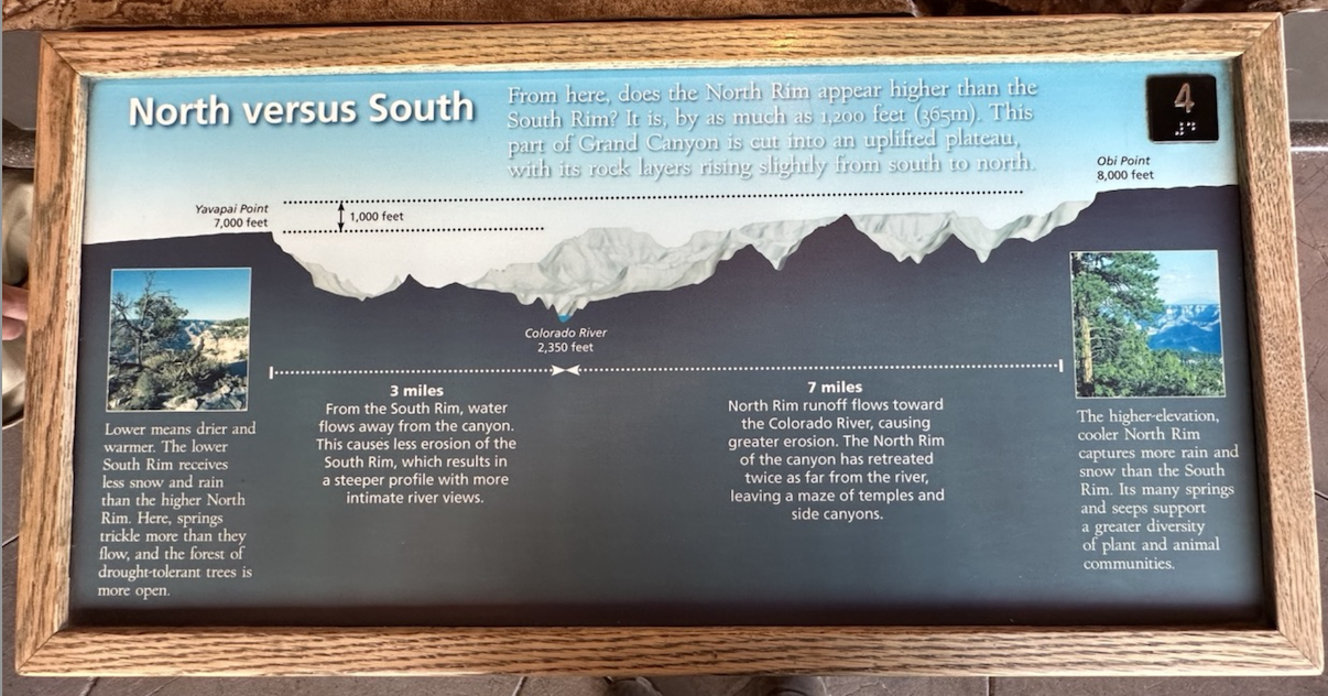
North versus South - From here, does the North Rim appear higher than the South Rim? It is, by as much as 1.200 feet (365m). This part of Grand Canyon is cut into an uplifted plateau, with its rock layers rising slightly from south to north . / Lower means drier and warmer. The lower South Rim receives less snow and rain than the higher North Rim. Here, springs trickle more than they flow, and the forest of drought-tolerant trees is more open. / The higher-elevation, cooler North Rim captures more rain and snow than the South rim. Its many springs and seeps support a greater diversity of plant and animal communities./ From the South Rim, water flows away from the canyon. This causes less erosion of the South Rim, which results in a steeper profile with more intimate river views. North Rim runoff flows toward the Colorado River, causing greater erosion. The North Rim of the canyon has retreated twice as far from the river, leaving a maze of temples and side canyons.
북쪽 대 남쪽 - 여기서 보면 North Rim이 South Rim보다 높게 보이는가? 이 높이 차이는 1,200피트(365m) 정도이다. 그랜드 캐년의 이 부분은 융기된 고원으로 깎여져 있으며, 암석층은 남쪽에서 북쪽으로 약간 솟아있다. / 낮으면 더 건조하고 따뜻하다는 뜻이다. 낮은 South Rim은 높은 North Rim보다 눈과 비의 양이 적다. 여기에서는 샘이 흐르는 것보다 조금씩 흐르는 것이 더 많고, 가뭄에 강한 나무들의 숲이 더 탁 트여 있다. / 고도가 높고 시원한 North Rim은 South Rim보다 비와 눈이 더 많이 내린다. 이곳의 많은 샘과 샘은 더욱 다양한 식물과 동물 군집을 지원한다./ South Rim 에서 물은 협곡에서 흘러나온다. 이는 South Rim의 침식을 줄여 더욱 친밀한 강 전망과 함께 가파른 지형을 보여준다. North Rim의 유출수는 콜로라도 강으로 흘러가며 더 큰 침식을 일으킨다. 협곡의 북쪽 가장자리는 강에서 두 배나 멀리 후퇴하여 Temple과 옆 협곡의 미로를 남겼다.

" The Grand Canyon is the sublimest on earth… by virtue of the whole - its ensemble" - Clarence Dutton
A Canyon of Enormous Proportions - Grand Canyon may not be the longest or deepest or widest canyon in the world, but most people would agree that it is the grandest. The Canyon reveals a wealth of geologic information, nearly 2,000 million years of Earth's history within its canyon walls. / What you see from Yavapai Point Museum, and outlined here, is only a fraction of the larger Grand Canyon. /Long - The canyon, from Lees Ferry to Grand Wash Cliffs, is 277 river miles (446km) ling. Floating the length of the river through the canyon takes 14 to 21 days in an oared raft, or 7 to 10 days ina motorized raft. / Wide - The Canyon varies in width from less than a mile to over 18 miles (1.5 to 29 km) but averages 10 miles (16km) wide. No roads cross the canyon between Navajo Bridge (Lees Ferry) and Hoover Dam for 340 miles (547 km). / Deep- At its deepest, the Colorado River flows 6,093 feet (1,857 m) below the North Rim. Overall, Grand Canyon averages 1 mile (1.6km) deep. Hikers take a full day to walk the 10 miles (16km) form the South Rim to the river and another day or two to walk the 14 miles (22.5 km) from the river ot the North Rim.
"그랜드 캐년은 지구상에서 가장 숭고하다… 전체의 힘으로 - 그 앙상블" - Clarence Dutton
A Canyon of Enormous Proportions - 그랜드 캐년은 세계에서 가장 길거나 깊거나 가장 넓은 협곡은 아닐 수도 있지만 대부분의 사람들은 동의할 것이다. 이것은 가장 웅장하다는 것. 캐년은 협곡 벽 내에서 거의 20억년에 달하는 지구 역사를 포함한 풍부한 지질학적 정보를 보여준다. / 야바파이 포인트 박물관(Yavapai Point Museum)에서 볼 수 있는 것과 여기에 설명된 것은 더 큰 그랜드 캐니언의 극히 일부에 불과하다. /Long - Lees Ferry에서 Grand Wash Cliffs까지의 협곡 길이는 446km이다. 협곡을 통해 강을 따라 떠다니는 데는 노를 젓는 뗏목의 경우 14~21일이 걸리고, 동력 뗏목의 경우 7~10일이 걸립린다. / 넓음 - 협곡의 폭은 1마일 미만부터 18마일(1.5~29km)까지 다양하지만 평균 폭은 10마일(16km)이다. 나바호 다리(리스 페리)와 후버 댐 사이의 547km(340마일) 동안 협곡을 건너는 도로는 없다. / 깊은 곳 - 콜로라도 강은 가장 깊은 곳에서 North Rim 아래로 1,857m(6,093피트)를 흐른다. 전반적으로 그랜드 캐니언의 평균 깊이는 1마일(1.6km)이다. 등산객들은 린South Rim 에서 강까지 16km를 걷는 데 하루 종일 걸리고, 강에서 North Rim 까지 22.5km를 걷는 데 하루나 이틀이 걸린다.
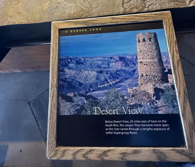
Desert View - Below Desert View, 25 miles east of here on the South Rim, the canyon floor becomes more open as the river carves through a lengthy exposure of softer Supergroup Rocks.
데저트 뷰(Desert View) - 여기에서 동쪽으로 25마일 떨어진 사우스 림(South Rim)에 있는 데저트 뷰(Desert View) 아래에는 강이 더 부드러운 슈퍼그룹 암석(Supergroup Rocks)을 오랫동안 노출시켜 깎아내림에 따라 협곡 바닥이 더욱 넓어진다.

Cape Royal: The panorama from Cape Royal on the North Rim contrasts the rugged Grand Canyon with the broad expanses of mesas and plains in the colorful Painted Desert beyond.
케이프 로얄(Cape Royal): North Rim 에 있는 케이프 로얄(Cape Royal)의 파노라마는 울퉁불퉁한 Grand Canyon 과 그 너머 다채로운 페인티드 사막(Painted Desert)의 광활한 암석 및 평야와 대조를 이룬다.

Point Sublime - The view west from North Rim's Point Sublime shows a subtle change in the canyon’s profile. A broad platform, the Esplanade, makes its first appearance 1,500 feet (450m) below the rims.
포인트 서브라임(Point Sublime) - North Rim의 포인트 서브라임(Point Sublime) 서쪽 전망은 협곡의 윤곽에 미묘한 변화를 보여준다. 넓은 플랫폼인 에스플러네이드(Esplanade)는 테두리 아래 450m(1,500피트) 높이에서 처음으로 모습을 드러낸다.

Canyon in a Canyon - The Colorado River is no wider today than it was 5 million years ago. The river cuts down, not out. Its incision triggers tributaries to carve side canyons in an ever-spreading web of erosion. With enough time and gravity, water dominates rock. / The Sides Fall In - Erosion of differing rock layers creates the canyon's stair-step shape. Softer, slope-forming layers erode more easily, undermining harder, cliff-forming layers above. Gravity pulls down the undercut cliffs, causing them to retreat. / A Firm Foundation - Terraces of relatively young rock layers sit on the dense, ancient Basement Rocks, through which the Colorado River now cuts its V-shaped inner gorge. / Dynamic Balance - Drawn down by gravity, the river erodes toward sea level- the river's end. The side streams follow but can erode only as deep as the Colorado River's elevation.
협곡 속의 협곡 - 콜로라도 강은 오늘날 500만년 전보다 더 넓지 않았다. 강은 없어지지않고 수량이 줄어들었다. 그 절개는 지류가 끊임없이 퍼지는 여러 침식에서 측면 협곡을 조각하도록 촉발했다. 충분한 시간과 중력이 있으면 물이 암석을 지배한다. / 측면이 무너짐 - 서로 다른 암석층의 침식으로 인해 협곡의 계단 모양이 만들어진다. 더 부드러운 경사면을 형성하는 층은 더 쉽게 침식되어 위의 더 단단한 절벽을 형성하는 층을 약화시킨다. 중력이 밑둥이 잘린 절벽을 끌어내려 더 뒤로 후퇴하게 만든다. / 견고한 기초 - 상대적으로 젊은 암석층으로 이루어진 테라스가 밀도가 높은 고대 지하 암석 위에 자리잡고 있으며, 현재 콜로라도 강이 V자 모양의 내부 협곡을 통과하고 있다. / 동적 균형 - 중력에 의해 강이 해수면, 즉 강 끝을 향해 침식된다. 측면 하천이 따라오지만 콜로라도 강의 고도만큼만 침식될 수 있다.
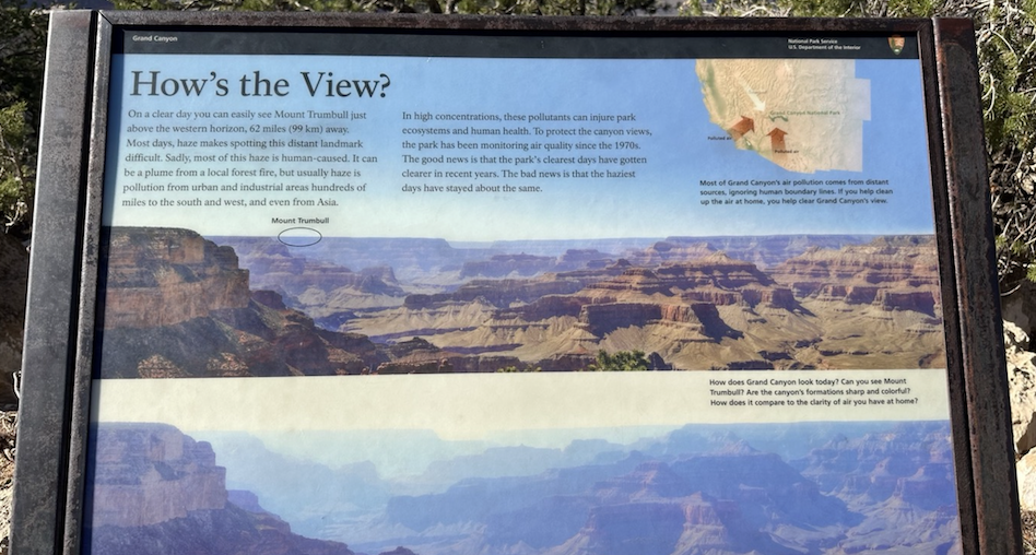
How's the View? - On a clear day you can easily see Mount Trumbull just above the western horizon, 62 miles (99km) away. Most days, haze makes spotting distance landmark difficult. Sadly, most of this haze is human-caused. It can be a plume from a local forest fire, but usually haze is pollution from urban and industrial areas hundreds of miles to the south and wet, and even from Asia. In high concentrations, these pollutants can injure park ecosystems and human health. To protect the canyon views, the park has bee monitoring air quality since the 1970s. The good news is that the park's clearest days have gotten clearer in recent years. The bad news is that the haziest days have stayed about the same.
경관은 어떤가? - 맑은 날에는 서쪽 지평선 바로 위, 99km 떨어진 트럼불 산을 쉽게 볼 수 있다. 대부분의 경우 안개로 인해 거리의 랜드마크를 발견하기가 어렵다. 안타깝게도 이 안개의 대부분은 인간이 원인이다. 이는 지역 산불로 인한 연기일 수 있지만 일반적으로 연무는 남쪽으로 수백 마일 떨어진 도시 및 산업 지역, 습한 지역, 심지어 아시아에서도 발생하는 오염이다. 농도가 높으면 이러한 오염 물질은 공원 생태계와 인간 건강에 해를 끼칠 수 있다. 협곡의 경관을 보호하기 위해 공원에서는 1970년대부터 대기 질을 모니터링해 왔다. 좋은 소식은 최근 몇 년 동안 공원의 가장 맑은 날이 더 맑아졌다는 것이다. 나쁜 소식은 가장 흐릿한 날이 거의 그대로 유지되었다는 것이다.

People have live here for over 10,000 years. Today, at least 12 Native American tribes think of Grand Canyon as part of their homeland. The canyon's grandeur attracts millions of visitors each year from all over the world. / 150 years ago: John Wesley Powell led the first geologic exploration through Grand Canyon in 1869. / 1000 years ago - Ancestral Puebloans farmed the canyon bottom. These rooms were used to store their crops. / 4000 years ago - Paleo-Indians made split-twig figures. These 4,000-year-old figurines have been found in caves. They are some of the oldest human-made artifacts in Grand Canyon. /10,000 years ago - Nomadic hunters lived here 10,000 years ago. They may have influenced the extinction of large mammals like the Shasta Sloth.
사람들은 이곳에서 10,000년 넘게 살았다. 오늘날 최소한 12개의 아메리카 원주민 부족이 그랜드 캐년을 자신들의 고향의 일부로 생각한다. 협곡의 웅장함은 매년 전 세계에서 수백만 명의 방문객을 끌어 모으고 있다. / 150년 전: 존 웨슬리 파월(John Wesley Powell)은 1869년에 그랜드 캐년을 통한 최초의 지질 탐험을 이끌었다. / 1,000년 전 - 조상 푸에블로인들이 협곡 바닥에서 농사를 지었다. 이 방은 농작물을 저장하는 데 사용되었다. / 4,000년 전 - 고대인디언들은 나뭇가지가 쪼개진 형상을 만들었다. 이 4,000년 된 조각상은 동굴에서 발견되었다. 이는 그랜드 캐년에서 인간이 만든 가장 오래된 유물 중 일부이다. /10,000년 전 - 10,000년 전 이곳에는 유목민 사냥꾼들이 살았다. 그들은 샤스타 나무늘보와 같은 대형 포유류의 멸종에 영향을 미쳤을 수 있다.
-

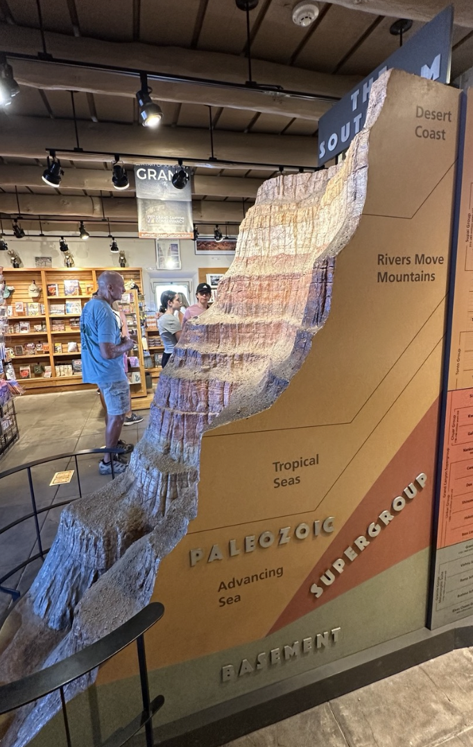
Hiding in the Basement- For five million years the Colorado River sliced through layer after layer, cutting into the very foundation of the continent - the Basement Rocks. Buried beneath almost 4,000 feet of younger rocks, the Basement Rocks are Grand Canyon’s oldest and toughest rocks. They confine the river in a steep, narrow inner Gorge.
지층 기저부에 숨어 - 500만 년 동안 콜로라도 강은 층층이 갈라져 대륙의 기초인 지하 암석을 깎아냈다. 약 4,000피트의 어린 암석 아래에 묻혀 있는 Basement Rocks 는 그랜드 캐년에서 가장 오래되고 가장 견고한 암석이다. 그들은 가파르고 좁은 내부 협곡에 강을 가두어 둔다.


Climate changes affect ecology, geology, and you. - 20,000 years ago, Grand Canyon was in a much cooler and wetter climate cycle. Imagine how past global climate cycles affected Grand Canyon. Warmer and dryer times were similar to today's climate and vegetation. Cooler and wetter times had heavily forested canyon walls. Find the bands in trees and rocks. Nature records climate change in these bands. Cave deposits and spring deposits record 1,000s to 100,000s of years.
기후 변화는 생태, 지질학, 그리고 우리들에게 영향을 미친다. - 20,000년 전, 그랜드 캐년은 훨씬 더 시원하고 습한 기후 주기에 있었다. 과거의 글로벌 기후 주기가 그랜드 캐니언에 어떤 영향을 미쳤는지 상상해 보라. 더 따뜻하고 더 건조한 시기는 오늘날의 기후 및 식생과 유사했다. 더 시원하고 습한 시기에는 협곡 벽에 숲이 우거져 있었다. 나무와 바위에서 띠를 찾아보라. 자연은 이 밴드에서 기후 변화를 기록한다. 동굴 퇴적물과 샘 퇴적물은 1,000~100,000년을 기록한다.

Eruptions and earthquakes may happen here again. - 100,000 years ago volcanoes erupted west of here. Even today, volcanoes, earthquakes and erosion work together to shape this spectacular landscape. / Lava flows dammed the Colorado River. Volcanoes, like this one sent lava flows cascading into Grand Canyon. / Imagine viewing an eruption! Pottery fragments have been found in 1,000-year-old lava flows suggesting that people witnessed these eruptions.
이곳에서는 또다시 폭발과 지진이 일어날 수 있다. - 10만 년 전 이곳 서쪽에서 화산이 폭발했다. 오늘날에도 화산, 지진, 침식이 함께 작용하여 이 멋진 풍경을 형성하고 있다. / 용암류가 콜로라도 강을 막았다. 이와 같은 화산은 용암류를 그랜드 캐니언으로 쏟아부었다. / 분출하는 모습을 상상해 보라! 1,000년 된 용암류에서 도자기 파편이 발견되어 사람들이 이러한 폭발을 목격했음을 암시한다.

Without uplift there would be no Grand Canyon - The Colorad Plateau region was lifted high above sea level. The high elevation set the stage for the later carving of Grand Canyon. / 100 million years ago - Before the uplift, 3 kilometers (2 miles) of sedimentary rock layers accumulated as seas advanced and retreated many times. / 60 million years ago - the Colorado Plateau was uplifted and compressed due to distant plate collision. This caused the upper sedimentary layers to slowly erode away. / Today - Erosion has stripped away a 2 kilometer (1.2 mile) thickness of rock. Today, the Colorado River continues to carve through this uplifted region. / Imagine the rocks that used to be here - Layer containing dinosaur fossils have been removed by erosion.
융기가 없으면 그랜드 캐년도 없을 것이다. - 콜로라도 고원 지역은 해수면보다 높게 솟아올랐다. 높은 고도는 나중에 그랜드 캐년을 조각하기 위한 무대를 마련했다. / 1억년 전 - 융기 이전에는 바다가 여러 번 전진하고 후퇴하면서 3km의 퇴적암층이 쌓였다. / 6천만년 전 - 콜로라도 고원은 먼 판의 충돌로 인해 융기되고 압축되었다. 이로 인해 상부 퇴적층이 천천히 침식되었다. / 오늘 - 침식으로 인해 2킬로미터(1.2마일) 두께의 암석이 벗겨졌다. 오늘날 콜로라도 강은 이 융기 지역을 계속해서 깎고 있다. / 여기에 있었던 암석을 상상해 보라. - 공룡 화석이 포함된 층이 침식으로 제거되었다.

The top layer is 270 million years old. - The horizontal layers were deposited as sediments, over millions of years. Each layer covered the one below. Time, pressure, and burial turned them into sedimentary rocks. / Find the fossils. 270 million years ago, this region was a tropical sea. These are the remains of animals that lived in the sea and became fossilized in the Kaibab Limestone.
최상층의 나이는 2억 7천만년이다. - 수평층은 수백만 년에 걸쳐 퇴적물로 퇴적되었다. 각 레이어는 아래 레이어를 덮었다. 시간, 압력, 매장으로 인해 퇴적암이 되었다. / 화석을 찾아보라. 2억 7천만년 전 이 지역은 열대 바다였다. 바다에 살다가 카이바브 석회암에서 화석화된 동물들의 잔해다.
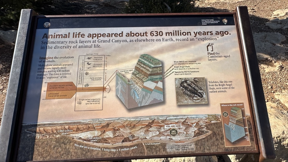
Animal life appeared about 630 million years ago. - Sedimentary rock layers at Grand Canyon, as elsewhere on Earth, record an "explosion" in the diversity of animal life. / Imagine the evolution of animals. Multicellular animals appeared and became rapidly more complex starting 630 million years ago. This time is referred to as an "explosion" of life.
동물의 생명은 약 6억 3천만년 전에 나타났다. - 지구상의 다른 곳과 마찬가지로 그랜드 캐년의 퇴적암층도 동물의 다양성이 '폭발'했다는 기록을 남겼다. / 동물의 진화를 상상해 보라. 다세포 동물이 출현하고 6억 3천만년 전부터 더욱 복잡해졌다. 이시기를 생명의 '폭발'이라 부른다.

1.2 billion years is missing from the rock record. - Gaps in the rock record are called unconformities. They represent times when rocks were eroded from the rock record, like chapters torn from a book. / 1,720 million years ago - Basement rocks formed deep below the Vishnu Mountains. / 1,250 million years ago - Erosion leveled the mountains: 20 kilometers (12 miles) of rock was gone. / 500 million years ago - New layers of rock were deposited by an advancing sea.
암석 기록에는 12억년이 빠져 있다. - 암석 기록의 공백을 부정합이라고 한다. 그것은 책에서 찢어진 장처럼 바위가 암석 기록에서 침식된 시대를 나타낸다. / 17억 2천만년 전 - 비슈누산맥 깊은 곳에서 지하암이 형성되었다. / 12억 5천만년 전 - 침식으로 인해 산이 평평해졌다. 20킬로미터(12마일)의 암석이 사라졌다. / 5억년 전 - 전진하는 바다에 의해 새로운 암석층이 퇴적되었다.

The Mighty Colorado? Can you spot the Colorado River? It looks tiny, surrounded by the vast Grand Canyon, but do not be deceived. Its racing, muddy waters carved the one-mile (1.6 km) depth of Grand Canyon. Standing on the canyon's edge you may feel distant and disconnected from the river. But our connection is strong; our thirst for its waters is relentless in the desert Southwest. Today, cities and farms consume the Colorado River before it ever reaches the sea.
Olympic Medalist? In 1963, Lake Powell began backing up behind Glen Canyon Dam, just upstream of Grand Canyon. The dam holds back the Colorado River's canyon-carving power. Still, 128,040 gallons (484,684 liters) per second surges through the inner Gorge during normal dam operations. That much water would fill an Olympic-size pool in only five seconds. Perhaps the river deserves a gold medal?
Can you find the bridge in the view? It spans 440 feet (123 m), carrying hikers and mules 70 feet (21 m) above the river to nearby Phantom Ranch.
마이티 콜로라도? 콜로라도 강이 보이시나요? 광대한 그랜드 캐니언에 둘러싸여 있어 작아 보이지만 속지 마십시오. 질주하는 흙탕물이 그랜드 캐니언의 깊이 1마일(1.6km)을 깎아냈습니다. 협곡 가장자리에 서 있으면 강과의 거리감과 단절감을 느낄 수 있습니다. 하지만 우리의 연결은 강력합니다. 남서부 사막에서는 물에 대한 우리의 갈증이 끝이 없습니다. 오늘날 도시와 농장에서는 콜로라도 강이 바다에 도달하기도 전에 이를 소비합니다.
올림픽 메달리스트? 1963년에 파웰 호수는 그랜드 캐니언 바로 상류에 있는 글렌 캐년 댐 뒤에서 백업을 시작했습니다. 댐은 콜로라도 강의 협곡을 깎는 힘을 억제합니다. 그러나 정상적인 댐 작동 중에는 초당 128,040갤런(484,684리터)의 물이 협곡 내부를 통해 급증합니다. 그 정도의 물은 단 5초 만에 올림픽 규모의 수영장을 채울 수 있습니다. 아마도 강은 금메달을 받을 자격이 있을까요?
뷰에서 다리를 찾을 수 있나요? 길이는 123m(440피트)에 달하며 강 위 21m(70피트) 높이의 등산객과 노새를 인근 팬텀 랜치(Phantom Ranch)까지 운반합니다.

 헝가리 Walk along the Danube in Budapest 08/16-20/2024
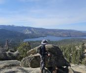
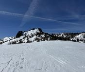
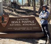 Minaret Lake & Devils Postpile in Sierra Nevada 09/21/2024

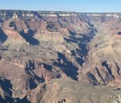

붉은 화살표 Yavapai Point에서 내려다 보는 Grand Canyon은 그야말로 장관이다. 저 겹겹이 쌓여있은 지층들을 다음 도표에서 3가지 크게 나누어 설명하고있다. Paleozoic Rocks (고생대 암석), Supergroup, Vishnu Basement Rocks.
Grand Canyon’s Three Sets of Rocks
Figure 24. Stratigraphic column of rocks of the Grand Canyon region showing the three sets of rocks and major unconformities: Great Nonconformity (white line), Great Angular Unconformity (red line) and Great Unconformity (black line). Fm = Formation; Ss = Sandstone; Ls = Limestone. 세 세트의 암석과 주요 부정합을 보여주는 그랜드 캐니언 지역 암석의 층위학적 Column: Great Nonconformity(흰색 선), Great Angular Unconformity(빨간색 선)와 Great Unconformity(검은색 선)이다. Fm = 형성; Ss = 사암; Ls = 석회암
Grand Canyon 이 지형학적으로 아주 유명한 이유는 바로 위 빨간줄로 표시된 대부정합때문이다.
대부정합(Great Unclnformity)은 층층이 쌓인 암석 간의 나이가 10억년 이상 상당한 격차를 나타내는 곳이다. 침식으로 인해 이전에 퇴적된 암석층이 제거되어 지구 역사의 증거가 지워지는 상당히 오랜 시간을 의미한다. 대부정합은 암석 기록에서 누락된 방대한 양의 지질학적 시간을 나타내기 때문에 지질학자들에게 매우 중요하다. 대부정합 아래에는 Grand Canyon 에서 발견된 가장 오래된 암석 중 일부인 선캄브리아기 암석이 있다. 이 암석은 편암, 편마암, 화강암을 포함하며 변성 및 심성 활동과 같은 다양한 과정을 통해 형성이 되었는데 그들은 약 17억년에서 5억 4천만년 전까지의 시간 범위를 나타낸다. 이는 침식 작용으로 이전에 퇴적된 지층이 제거되어 산 형성, 화산 활동, 해수면 변화와 같은 주요 지질학적 사건의 증거를 잃어버린 상당히 오랜 기간을 나타낸다. 대부정합 상부에는 고생대 퇴적암이 발견이 되는데 이 퇴적층은 약 5억 4천만년에서 2억 5천만 년 전의 고생대에 퇴적 되었다. 처음에는 선캄브리아기 암석이 퇴적된 후 융기 및 침식을 겪었고 이 침식은 지각 활동과 변화하는 환경조건으로 인해 상당한 양의 암석층이 제거되었다. 그 후 이 지역은 다시 물에 잠겼고 고생대 퇴적암이 침식된 표면 위에 퇴적되었다.
What’s Missing?
Rock layers record time. Sometimes rocks erode away, and we lose that record. Some 5,000 feet of rock has already eroded from the top of Grand Canyon, deleting the stories of the most recent 270 million years, including the time of the dinosaurs. Where Paleozoic Rocks rest directly on Basement Rocks, the contact represents a gap of 1,150 million years. Geologists call this gap the Great Unconformity. Wedges of Supergroup Rocks, where present, record some of this missing time.
무엇이 빠졌나?
암석층은 시간을 기록한다. 때때로 암석은 침식되어 그 기록을 잃게 된다. 약 5,000피트의 암석이 이미 그랜드 캐년 꼭대기에서 침식되어 공룡 시대를 포함하여 가장 최근 2억 7천만년의 역사를 삭제되었다. 고생대 암석이 기저 암석 위에 바로 놓여 있는 경우 접촉은 11억 5천만년의 간격을 나타낸다. 지질학자들은 이 격차를 대부정합(Great Unconformity)이라고 부른다. Supergroup Rocks의 쐐기(Wedges of Supergroup Rocks)가 존재하는 경우 이러한 누락된 시간의 일부를 기록한다.
Grand Canyon 만큼 지질학의 살아있는 교육은 없다고 본다. 특히, Grand Canyon Trail of Time 은 강추!
Grand Canyon Trail of Time
The Trail of Time is an interpretive walking trail that focuses on Grand Canyon's vistas and rocks, encouraging visitors to ponder, explore, and understand the magnitude of geologic time and the stories told by canyon's rock layers and landscapes. Walking the trail is intended to give park visitors a visceral appreciation for the magnitude of geologic time...This 4.56 km (2.83 mile) long trail is actually a geologic time-line. Each meter on the trail signifies one million years of Grand Canyon's geologic history; and bronze markers mark one meter intervals. Every tenth marker is labeled in millions of years. NPS Photo by Erin Whitakker. For more information: tot.unm.edu/
그랜드 캐니언 시간의 흔적
시간의 흔적(Trail of Time)은 그랜드 캐년의 경치와 암석에 초점을 맞춘 해석적 산책로로, 방문객들이 지질학적 시간의 규모와 협곡의 암석층과 풍경이 전달하는 이야기를 숙고하고, 탐험하고, 이해하도록 장려했다. 트레일을 걷는 것은 공원 방문객에게 지질학적 시간의 규모에 대한 본능적인 감사를 제공하기 위한 것이다. 이 4.56km(2.83마일) 길이의 트레일은 실제로 지질학적 연대표이다. 트레일의 각 미터는 그랜드 캐년의 지질학적 역사의 100만 년을 의미한다. 청동 마커는 1미터 간격을 표시한다. 매 10번째 마커는 수백만 년 단위로 표시된다. 더 많은 정보를 원하시면: tot.unm.edu/
History of the Trail
The concept of a scaled geologic walking trail, along the heavily-visited South Rim, was originally conceived in 1995 by Dr. Karl Karlstrom and Dr. Michael Williams as a way to improve geoscience interpretation at Grand Canyon and connect research advances to public geoscience education. In 2001 Dr. Karl Karlstrom and Dr. Laura Crossey began applying for funding from the National Science Foundation to implement the project. Major progress on the project started in 2006 when funding was obtained from the National Science Foundation Informal Science Education Program. Since then the Trail of Time has grown to include Dr. Steve Semken (at Arizona State University), Ryan Crow (at University of New Mexico), many partners at Grand Canyon National Park, professional exhibit designers at Jim Sell Designs, and professional evaluators at Selinda Research Associates, among others. Figure of proposed trail A portion of the Trail as conceived in 1995
트레일의 역사
방문객이 많은 사우스 림(South Rim)을 따라 확장된 지질학적 산책로라는 개념은 원래 1995년에 칼 칼스트롬(Karl Karlstrom) 박사와 마이클 윌리엄스(Michael Williams) 박사가 그랜드 캐년의 지구과학 해석을 개선하고 연구 발전을 공공 지구과학 교육과 연결하기 위한 방법으로 고안했다. . 2001년에 Karl Karlstrom 박사와 Laura Crossey 박사는 이 프로젝트를 구현하기 위해 국립 과학 재단에 자금 지원을 신청하기 시작했다. 프로젝트의 주요 진전은 2006년 국립과학재단 비공식 과학 교육 프로그램으로부터 자금 지원을 받으면서 시작되었다. 그 이후로 Trail of Time은 Steve Semken 박사(애리조나 주립 대학교), Ryan Crow(뉴멕시코 대학교), Grand Canyon 국립공원의 많은 파트너, Jim Sell Designs의 전문 전시 디자이너 및 전문 평가자들이 포함되었다.
'Trail of Time '에서 눈에 띄는 암석은 역시 가장 오래된 편암인 Vishnu schist 였다. 17억년전 지층이 변성된 것이라니… 지질학의 나이는 상상을 초월한다.
The Proterozoic Vishnu schist, the oldest exposed rocks of the canyon, mountain building episodes occurred 1.7 billion years ago. Grand Canyon 협곡의 가장 오래전에 노출된 암석인 원생대의 비슈주 편암은 17억년 전에 일련의 조산운동으로 만들어졌다.
2.7억년전이라… 페름기에 해당된다. 암모나이트, 산호초, 곤충들이 지구를 덮었던 시대이다. 이시기 마지막에 대멸종이 일어나면서 지구상의 95%에 달하는 생물종이 사라지게 된다.
누가 살고 있었을까? 원주민인 Pueblo, Hopi, Yavapai, Navajo Indian (위사진 차례대로) 이 거주하고 있었다.
백인들은? 1540년 이 지역을 탐사하던 스페인 코로나도 탐험대의 Lopez de Cardenas가 최초로 Grand Canyon에 들어왔다.
In 1539, Friar Marcos de Niza, a Franciscan priest, reported to Spanish colonial officials in Mexico City that he’d seen the legendary city of Cibola. Viceroy Mendoza, on January 6, 1540, appointed Francisco Vázquez de Coronado to lead an expedition to conquer the area. In February 1540, Coronado’s route, began in what is now Puerto Vallarta on the west coast of Mexico, heading north through the Sinaloa and Sonora deserts, and headed north on trails that parallels today’s border of Arizona and New Mexico. It was a medieval-looking army of 350 European men-at-arms, a large number of spouses, African slaves, and servants, and as many as 2,000 Mexican Indian allies, mostly warriors from Aztec, Tarascan, and other tribes from central and western Mexico, 540 saddle horses for the caballeros, 960 pack horses and mules, and cattle, sheep and pigs for the expedition commissary. On July 7, 1540, Coronado’s large military expedition made its way to the villages of the Cibola (the present day Zuni Reservation of west central New Mexico) where a major battle occurred between the Zunis and the Spaniards in which Coronado narrowly escaped death. It is likely that the horses and sheep with Coronado were the first the Zunis had ever seen. Juan Galeras, and a third, unnamed soldier to descend into the Canyon and report back about the river below. After descended some 1/3 of the way they were forced to return because of lack of water. In their report, they noted that some of the rocks in the Canyon were “bigger than the great tower of Seville.” Without water, the Cardenas detachment remained only three days on the Canyon rim.
1539년 프란체스코회 신부 마르코스 데 니자(Marcos de Niza) 수사는 멕시코 시티에 있는 스페인 식민 관리들에게 전설적인 도시 시볼라를 보았다고 보고했다. 1540년 1월 6일 멘도사 총독은 프란시스코 바스케스 데 코로나도를 임명하여 이 지역을 정복하기 위한 원정대를 이끌었다. 1540년 2월 코로나도의 경로는 현재 멕시코 서해안의 푸에르토 발라타에서 시작되어 시날로아와 소노라 사막을 거쳐 북쪽으로 향했고, 오늘날의 애리조나와 뉴멕시코 국경과 평행한 산책로를 따라 북쪽으로 향했다. 350명의 유럽 무장병과 다수의 배우자, 아프리카인 노예, 하인, 그리고 2,000명이나 되는 멕시코 인디언 동맹국으로 구성된 중세풍의 군대였으며 대부분은 아즈텍, 타라스칸, 기타 중부 및 중부 및 기타 부족 출신이었다. 1540년 7월 7일, 코로나도의 대규모 군사 원정대는 시볼라(현재 뉴멕시코 중서부의 주니 보호구역) 마을로 향했고, 그곳에서 주니족과 스페인족 사이에 대규모 전투가 벌어졌고 코로나도는 가까스로 죽음을 면했다. 코로나도와 함께 있는 말과 양은 주니족이 처음으로 본 것일 가능성이 높다. 카르데나스는 파블로 데 멜그로사(Pablo de Melgrossa), 후안 갈레라스(Juan Galeras), 이름이 알려지지 않은 세 번째 군인에게 협곡으로 내려가 아래 강에 대해 보고하라고 명령했다. 1/3 정도 내려간 후 물이 부족하여 어쩔 수 없이 돌아왔다. 그들은 보고에서 협곡에 있는 암석 중 일부가 “세비야의 거대한 탑보다 더 컸다”고 지적했다. 물이 없었기 때문에 카르데나스 부대는 캐년 가장자리에 3일밖에 머물지 못했다.
그는 350명의 유럽 무장병과 다수의 배우자, 아프리카인 노예, 하인, 그리고 2,000명이나 되는 멕시코 인디언 동맹국으로 구성된 중세풍의 군대를 대동했다.
실제로 Grand Canyon을 세상에 알려지게 한 인물은 1869년 존 웨슬리 포웰 (John Wesley Powell)었다. 그는 남북 전쟁때 한쪽 팔을 잃어버린 외팔이 퇴역 소령. 4대의 보트로 72일간 파월 지리학 탐험대(Powell Geographic Expedition)를 이끌고 미국 남서부의 그린강과 콜로라도강의 최초 지도제작 및 과학적 조사를 하였다.
The Powell Geographic Expedition of 1869, led by American naturalist John Wesley Powell, was the first thorough cartographic and scientific investigation of long segments of the Green and Colorado rivers in the southwestern United States, including the first recorded passage of white men through the entirety of the Grand Canyon. The expedition, which lasted approximately three months during the summer of 1869, embarked from Green River Station, Wyoming Territory and traveled downstream through parts of the present-day states of Colorado and Utah before reaching the confluence of the Colorado and Virgin rivers in present-day Arizona and Nevada . Despite a series of hardships, including losses of boats and supplies, near-drownings, and the eventual departures of several crew members, the voyage produced the first detailed descriptions of much of the previously unexplored canyon country of the Colorado Plateau.
1869년 여름 동안 약 3개월 동안 지속된 탐험은 와이오밍 준주 그린리버역에서 출발하여 현재의 콜로라도주와 유타주 일부를 거쳐 하류로 여행한 후 현재 콜로라도강과 버진강의 애리조나와 네바다 합류점에 도달했다. 보트와 보급품의 손실, 거의 익사할 뻔한 상황, 결국 여러 명의 선원이 떠나는 등 일련의 어려움에도 불구하고 항해를 통해 이전에 탐험되지 않았던 콜로라도 고원의 협곡 지역 대부분에 대한 최초의 상세한 설명이 이루어졌다.
그 이후 Grand Canyon 개발 계획을 놓고 의견이 분분하였는데, 1908년 Theodore Roosevelt (1858 - 1919) 대통령의 지시로 National Monument로 지정되었고, 1919년에 미국 의회의 승인으로 국립공원으로 승격했다. 세계 7대 자연경관중의 하나로 꼽히는 Grand Canyon. 1979년에 유네스코 세계유산으로 지정되었고, 현재는 BBC가 선정한 죽기 전에 꼭 가봐야 할 곳 1위에 선정될 정도로 유명해졌다.
해마다 500만명이 몰려들어 매년 평균 12명이 사망하고 다수가 실종된다고 한다. 이날도 저 위험한 절벽에서 인생샷을 찍겠다고 모여있는 사람들이 보인다.
According to recent reports, the Grand Canyon has seen around 14-16 deaths in 2024, which is considered near the average annual death toll for the park, typically ranging between 10-15 fatalities per year; most deaths are attributed to factors like falls, drownings, heart attacks, and natural causes.
다음 웹사이트는 현재 진행되는 지질학 연구 동영상이다. 강추!
Scientists FOUND Something DISTURBING In The Grand Canyon.. This monumental find could change our understanding of this natural wonder forever.