Sanborn County Park 는 산 안드레아스 단층(San Andreas Fault) 위에 있다.
Sanborn County Park 는 산 안드레아스 단층(San Andreas Fault) 위에 있다.
Sanborn County Park 는 산 안드레아스 단층(San Andreas Fault) 이 지나가는 공원으로 유명하다. 산 안드레아스 단층은 공원 바로 아래를 지나가는데, 공원입구과 주요 주차장은 북미판(North American Plate)에 있다. 넓은 경사진 잔디밭을 가로질러 오르막길을 걷다 보면 단층대를 건너게 된다. 단층은 산에서 침식된 물질의 선상지층으로 덮여 있기 때문에 보이지 않는다. 캠프장 경로 하단에 있는 키오스크에 도달하면 Pacific Plate를 건너게 된다.
What happens if San Andreas Fault breaks?
Parts of the San Andreas Fault intersect with 39 gas and oil pipelines. This could rupture high-pressure gas lines, releasing gas into the air and igniting potentially deadly explosions.
샌안드레아스 단층이 깨지면 어떻게 되나?
산 안드레아스 단층의 일부는 39개의 가스 및 석유 파이프라인과 교차한다. 이로 인해 고압 가스 라인이 파열되어 가스가 공기 중으로 방출되고 잠재적으로 치명적인 폭발이 발화될 수 있다.
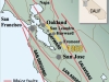
Predicting where and when the next “big one”
will strike the San Francisco Bay Area is a tough task for seismologist. Five major fault lines cross the Bay Area: San Andreas, Calaveras, San Gregorio, Hayward and Rodgers Creek.
A fault is defined by the U.S. Geological Survey as “a fracture or zone of fractures between two blocks of rock. Faults allow the blocks to move relative to each other. This movement may occur rapidly, in the form of an earthquake – or may occur slowly, in the form of creep.” Without enough creeping, pressure will build up until an earthquake results.
다음 "대지진"이 언제 어디서
샌프란시스코 베이 지역을 강타할 것인지 예측하는 것은 지진학자에게 어려운 작업이다. 베이 지역을 가로지르는 5개의 주요 단층선(산 안드레아스, 칼라베라스, 산 그레고리오, 헤이워드, 로저스 크릭). 미국 지질조사국(US Geological Survey)에서는 단층을 "두 암석 블록 사이의 균열 또는 균열 구역"으로 정의한다. 결함으로 인해 블록이 서로 상대적으로 이동할 수 있다. 이러한 움직임은 지진의 형태로 빠르게 발생할 수도 있고 크리프 형태로 천천히 발생할 수도 있다.”
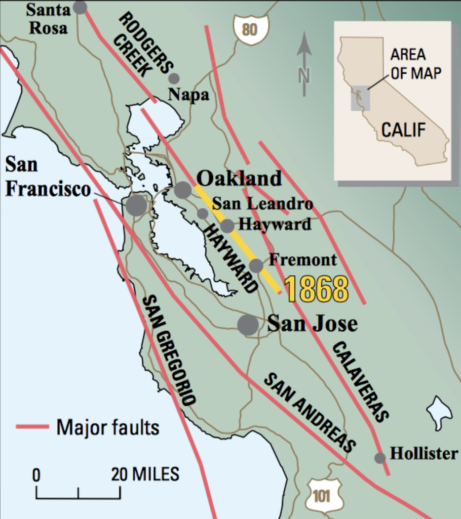
The Bay Area’s major fault lines (Image courtesy USGS)
Which Bay Area fault will rupture with a major earthquake, next?
“The Hayward Fault will rupture violently again, and perhaps soon,” USGS scientists wrote in its 2018 study. “The fault may be ready to produce another magnitude 6.8 to 7.0 earthquake.”
Seismic waves from the Hayward Fault unleashed a powerful earthquake on October 21, 1868. Its magnitude was estimated to be 6.8. Because seismographs had not yet been invented, there are no recordings of the quake. “The 1868 Hayward Fault earthquake is a reminder of the tremendous power that lurks beneath the Earth’s surface in the San Francisco Bay region,” USGS scientists wrote.
“Strong shaking lasted more than 40 seconds, devastating several East Bay towns. Brick buildings, walls, and chimneys were also shaken down in Oakland, San Francisco, Santa Rosa, and San Jose, and there was serious damage in Napa and Hollister. Numerous witnesses reported seeing the ground move in waves. Aftershocks rattled the Bay Area for weeks. Even though the region was only sparsely populated at the time, the1868 quake killed about 30 people,” USGS scientists wrote. In 1868, there were only about 24,000 residents living in Alameda County. Today, the county has 2.4 million, making the Hayward Fault the single-most urbanized earthquake fault in the United States.
다음에는 대지진으로 인해 어느 베이 지역 단층이 파열될까?
USGS 과학자들은 2018년 연구에서 "헤이워드 단층이 다시 격렬하게 파열될 것이며 아마도 곧 폭발할 것"이라고 썼다. “단층으로 인해 규모 6.8~7.0의 또 다른 지진이 발생할 가능성이 있다.” 헤이워드 단층에서 발생한 지진파는 1868년 10월 21일에 강력한 지진을 일으켰었다. 그 규모는 6.8로 추정되었다. 지진계가 아직 발명되지 않았기 때문에 지진에 대한 기록은 없다. USGS 과학자들은 “1868년 헤이워드 단층 지진은 샌프란시스코 베이 지역의 지표면 아래에 숨어 있는 엄청난 힘을 상기시켜준다”고 썼다.
“강한 흔들림이 40초 이상 지속되어 이스트베이(East Bay) 여러 마을을 파괴했다. 오클랜드와 샌프란시스코, 산타로사, 새너제이에서도 벽돌 건물과 담장, 굴뚝 등이 흔들리고 나파와 홀리스터에서도 심각한 피해가 발생했다. 수많은 목격자들이 땅이 파도처럼 움직이는 것을 목격했다고 보고했다. 여진은 몇 주 동안 베이 지역을 뒤흔들었다. 당시 이 지역에는 인구가 거의 없었음에도 불구하고 1868년 지진으로 인해 약 30명이 사망했다.” 1868년에는 앨러미다 카운티에 거주하는 주민이 약 24,000명에 불과했다. 현재 카운티에는 240만 명이 거주하고 있어 헤이워드 단층은 미국에서 가장 도시화된 지역 지진 단층이 되었다.
Why does California have so many earthquakes?
The answer can be traced back to 200 million years ago. The USGS explains, “This region of the United States has been tectonically active since the supercontinent Pangea broke up roughly 200 million years ago, and in large part because it is close to the western boundary of the North American plate. Since the formation of the San Andreas Fault system 25-30 million years ago, the juxtaposition of the Pacific and North American plates has formed many faults in California that accommodate lateral motion between the plates.” The Working Group for California Earthquake Probability assigned an 11% probability that the Calaveras Fault would produce a magnitude 6.7 or larger earthquake in the next 30 years. The Great 1906 San Francisco Earthquake had a catastrophic magnitude of 7.9. Massive fires ignited in San Francisco. The Bay Area’s most famous fault is the San Andreas Fault. It was responsible for both the Great 1906 San Francisco Earthquake and the 1989 Loma Prieta Earthquake.
캘리포니아에는 왜 지진이 많이 발생하는가?
그 답은 2억년 전으로 거슬러 올라간다. “미국의 이 지역은 약 2억년 전 초대륙 판게아가 분리된 이후로 구조적으로 활동적이었으며, 이는 주로 북미판의 서쪽 경계에 가깝기 때문이다. 2,500만~3,000만년 전 산안드레아스 단층계가 형성된 이후 태평양판과 북미판이 병치되면서 캘리포니아에서는 판 사이의 측면 운동을 수용하는 많은 단층이 형성되었다.” 캘리포니아 지진 확률은 칼라베라스 단층이 향후 30년 내에 진도 6.7 이상의 지진을 일으킬 확률을 11%로 지정했다. 1906년 샌프란시스코 대지진은 규모 7.9로 엄청난 규모를 기록했다.
What part of California is safest from earthquakes?
Sacramento is perhaps the best combination of city and safety in California. It has a bustling population of over half a million but has experienced only around 100 earthquakes in the past year. Most of these fail to register over a 2.0 in magnitude scale, which will not be noticeable for most.
캘리포니아의 어느 지역이 지진으로부터 가장 안전한가?
정답은 새크라멘토다. 새크라멘토는 아마도 캘리포니아에서 도시와 안전이 가장 잘 결합된 곳일 것이다. 인구는 50만 명이 넘지만 지난해 지진은 100회 정도만 겪었다. 이들 중 대부분은 규모 규모 2.0 이상으로 등록되지 않으며, 이는 대부분 눈에 띄지 않는 경미한 미진이다.
 Henry Cowell Redwood State Park
 Angel Island and Tiburon 08/18~19/2023 (금, 토)
-
Read MoreNo Image
Backcountry Weekend at Henry W. Coe State Park
동료한테 들었는데요. Backcountry Weekend at Henry W. Coe State Park 이란게 지난주말에 있었다네요. 매년 하지 않을까 싶어서 여기 올립니다. 내년에 하면 한번 가보는것도 좋겠네요. https://coepark.net/events/backcountry-weekend/ ttps://www.youtube... -
Read More
Huddart Park in Woodside, CA
Huddart Park https://www.huddartwunderlichfriends.org/huddart-park Native Americans thrived for centuries among the hills and gorges we now call Huddart Park. Known by various names, depending on which tribe they belonged to, the Native Amer... -
Read More
Henry Cowell Redwood State Park
Henry Cowell Redwoods State Park 가장 높은 redwood는 수령이 약 1,500년이고 높이는 277피트로 자유의 여신상보다 겨우 28피트 짧다. Coast Redwood, Giant Sequoia, Dawn Redwood등 알려진 세 가지 Redwood가 함께 자라고있다. 1800년대 중후반에 목재를 ... -
Read More
Sanborn County Park 는 산 안드레아스 단층(San Andreas Fault) 위에 있다.
Sanborn County Park 는 산 안드레아스 단층(San Andreas Fault) 위에 있다. Sanborn County Park 는 산 안드레아스 단층(San Andreas Fault) 이 지나가는 공원으로 유명하다. 산 안드레아스 단층은 공원 바로 아래를 지나가는데, 공원입구과 주요 주차장은 북... -
Read More
Angel Island and Tiburon 08/18~19/2023 (금, 토)
Bay Area의 보석같은 Angel Island는 San Francisco Bay에 있는 섬이다. Angel Island는 면적이 3.1㎢로 서울 여의도(2.9㎢)와 비슷하다. 캘리포니아의 역사적 랜드마크인 이 섬은 원주민의 계절별 사냥과 채집, 유럽 선박에 물과 목재 공급, 멕시코인의 목장,... -
Read MoreNo Image
베이 지역의 새로운 모습을 볼 수 있는 아름다운 하이킹 코스
이글은 Ann Marie Brown 의 글을 발췌해 옮긴 내용입니다 1. 맷 데이비스 앤 딥 래빈 루프(Matt Davis and Steep Ravine Loop) 타말파이어스산 주립공원 왕복 10마일 이 반나절짜리 순환 코스에는 타말파이스 산에서 가장 훌륭한 사진 촬영 명소가 있습니다. ...