본문 바로가기

skyline trail--> Logryhood Trail --> Service Trail --> skyline --> summit rock loop --> skyline trail : 약 8~9마일 예상. 

Skyline_SummitRockLoop.GIF

  • profile
    아리송 2016.03.18 10:57

    Course 2:


    Skyline_Summit_Skyline.JPG

    skyline trail(시작지점)--> Logryhood Trail --> Service Trail --> skyline --> summit rock loop --> skyline trail --> sunnyvale mountain trailhead(끝지점) -->  skyline trai (시작 지점): 총 15~16마일 정도 예상. (6~7시간) , 색깔있는 부분은 고도변화가 좀 있음.


    반대쪽 주차장: Sanborn CP의 다른 주차장.

    Skyline_endpoint.JPG


  • profile
    아리송 2016.03.18 10:58

    Course 3:

    Another Hiking Course: 고도변화가 많아보임.  스위치백구간이 많아서 그닥 가파르지 않음.

    Skyline<--> John Nicholas Trail : 총 11마일 가량.

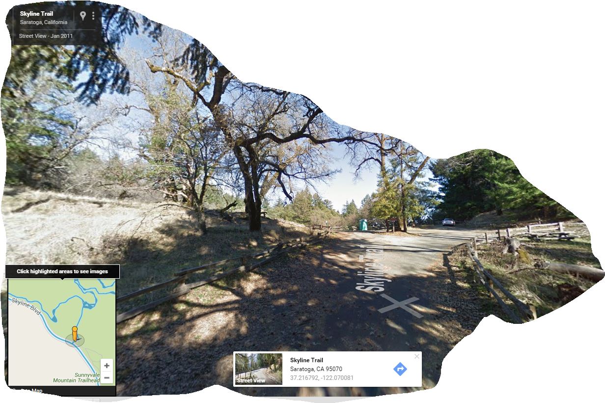
    Skyline에서  JN Trail로 갈경우 내리막산행으로 시작해서 점심후 오르막 산행이 되므로 좀 불편. 집결은 여기다하고 큰차 몇대로 JN TH로 이동후 산행을 시작하면 더 편리함. (점심은 아래 사진의 피크닉테이블 에서 모여서 하고 점심후산행은 내리막이므로 편리. 아니면 Indian Rock쪽으로 갔다와도 됨.


    JohnNicholasTrail.JPG


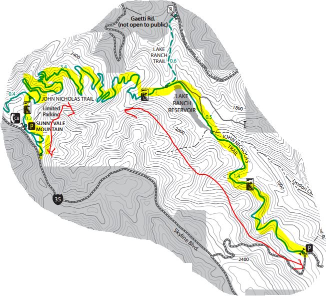
    Sunnyvale MT TH Parking Lot:


    SkylineParking.JPG


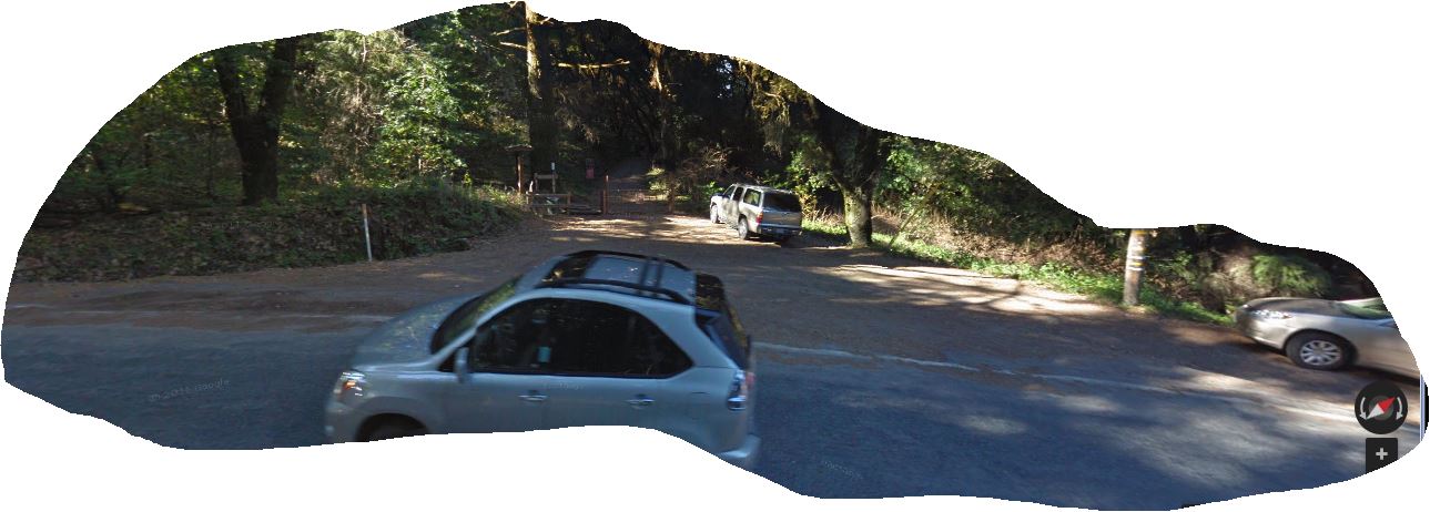
    John Nicolas TH Parking Lot: 차 4~5대가량 파킹가능할듯. 산악회 2차집결지로는 적당하지 않아 보임.

    JohnNicolasTH_Parking.JPG


    John Nicolas Trail Parking Lot 찾아 가는길


    Sunnyvale Mountain Trail Head Parking Lot 찾아가는길 

    (Hwy 9 에서 Hwy 35로 우회전해서 15.2Mi지점. Saratoga Gap Parking Lot에서 Castle Rock쪽으로 15.2 마일지점)

  • profile
    아리송 2016.03.18 10:59

    Course 4:


    Skyline--Sanborn Course : 이 조합도 1 day 산행코스로 괜찮을듯.(약 10마일 구간)
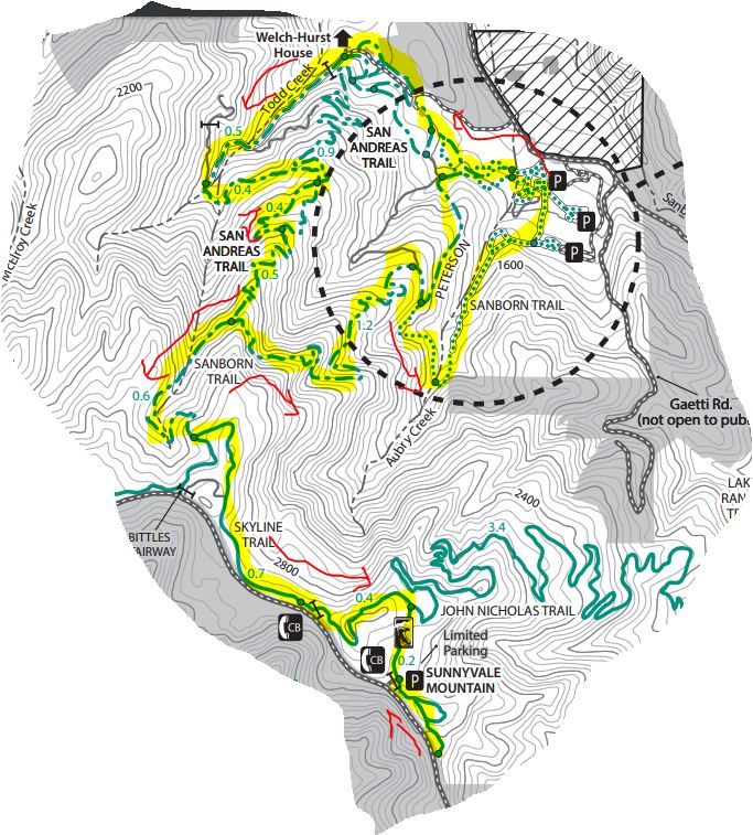
skyline_sanborn.JPG


    skyline_sanborn1.JPG

  • profile
    아리송 2016.03.18 11:02

    Course 5:


    SaratogaGAP1.JPG


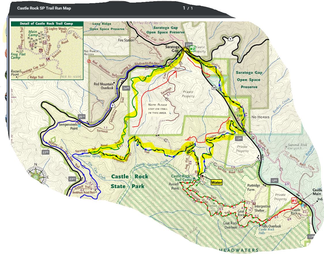
    Skyline --> Logrywood --> Castle Rock Trail Camp --> Travertine Springs Trail --> Saratoga Toll Road Trail : (13Mi, 2300ft)


    • 0.0 mi: Start out on the Skyline Trail. The trail will climb for a bit and then flatten out.
    • 1.1 mi: Stay left on the "Pedestrians Only" trail.
    • 1.5 mi: (EASY TO MISS) The Skyline Trail will run near the shoulder of Skyline Blvd and intersect a driveway. At this point, cross over Skyline Blvd and get on the Loghry Woods Trail. (Note: It is very hard to see the Loghry Woods Trail, but you can tell when to cross because this is the first time that the Skyline trail runs along the shoulder of Skyline Blvd.) The Loghry Woods Trail is a fun singletrack descent.
    • 3.3 mi: Loghry Woods Trail ends on the Service Road Trail. Turn right toward the campground.
    • 3.4 mi: (WATER) At the Castle Rock Trail Camp. Get water if needed, then continue along the Service Road. Veer left slightly to stay on the road, and then turn right onto the first singletrack, which is the Saratoga Gap Trail. After climbing down a rocky section you will pass a few small trails on your left, but stay right to head toward the Ridge Trail.
    • 3.5 mi: Veer left to get on the Ridge Trail. You will climb for a mile or so.
    • 4.3 mi: Pass the Connector Trail on your right. Stay on the Ridge Trail.
    • 4.6 mi: Keep right to continue on the Ridge Trail toward Goat Rock.
    • 4.8 mi: At Goat Rock. Say 'hi' to the rock climbers, then continue down the steps on the Ridge Trail.
    • 5.3 mi: Intersection with the Saratoga Gap Trail.  Cross the stream and make a hard right turn onto the Saratoga Gap Trail.
    • 5.4 mi: At the falls overlook. Stop, admire the falls, then continue on Saratoga Gap Trail for two miles. You will pass the Connector Trail on your right, and then get ready for some great views! You will also pass a section where a cable has been installed as a handhold because the trail is narrow and tricky.
    • 7.3 mi: Intersection with the Ridge Trail. Stay left to continue back towards the Castle Rock Trail Camp.
    • 7.4 mi: (WATER) Back at Castle Rock Trail Camp. Get water if needed, then start heading downhill on the Saratoga Gap Trail towards Saratoga Gap (this is a wide fire road). After crossing a bridge, keep an eye out on your left for Travertine Springs Trail.
    • 8.1 mi: Turn left onto Travertine Springs Trail. This trail is a great singletrack that first descends to the San Lorenzo Creek and then climbs back up to Saratoga Toll Road with spectacular views along the way. (Interesting factoid: The tiny San Lorenzo Creek turns into the big San Lorenzo River which flows through Felton and finally empties into the ocean in Santa Cruz.)
    • 10.2 mi: Travertine Springs Trail ends. Turn right onto the historic Saratoga Toll Road and start climbing! You will climb for about three miles.
    • 12.6 mi: Pass Skyline-to-the-Sea Trail on your left. Continue climbing on the Saratoga Toll Road towards Saratoga Gap.
    • 12.9 mi: Saratoga Toll Road Trail ends at Highway 9. Turn right and run along the shoulder to get back to the parking lot.
    • 13.0 mi: Back at your car!

  1. 배낭사이즈 선택을 위한 토르소측정법

    우리 베이산악회의 모든 게시판이 오로지 산에 관한 유익한 정보, 즉, 하이킹, 트레일과 백패킹 정보들로만 가득해지기를 기대합니다. 이번엔 백패킹을 위해 새로...
    By밴프 Reply0 Views2056 file
    Read More
  2. No Image

    개인간의 카톡내용을 공개할 수도 있군요

    Thursday, March 10, 2016 아싸님 나그넵니다 어제 자연님이 올린 글을 본 후 전화와 카톡으로 정상화 대책위원회 회의를 가졌습니다 회원간의 화합을 저해하고 ...
    By나그네 Reply0 Views331
    Read More
  3. No Image

    진달래님?

    제가 게시판 들어와 본지 오래 되어서 며칠 전 지나간 글들을 훑다가, 어느 횐님이 진달래님인지 (?) 비밀번호를 잊어버려서 못들어온다고 한 댓글을 본 기억이 ...
    Category알림 By지다 Reply4 Views218
    Read More
  4. The Wave!! 소개

    The Wave, Marble Canyon, Arizona 얼마 전에 다녀온 The Wave라는 곳을 소개 합니다. 송암, 소연님로부터 웨이브라는 곳에 대해 듣고 집으로 돌아와 검색해 보곤...
    By선비 Reply0 Views180 file
    Read More
  5. No Image

    3/26(토) 산행지 추천 받습니다.

    현재 운영진 산행계획방이 역할을 제대로 못하는 관계로 담주 로컬 산행공지 하실분들은 여기에 안을 올려주심 좋겠습니다. 부정기니까 두 군데 정도 올라와도 좋...
    Category제안 By아리송 Reply2 Views101
    Read More
  6. No Image

    산행정보방

    산행정보방은 산악회에서 다녀온 산행지에 대한 정보위주로 저장히는곳이고 현재 정회원님들만 참조할수 있는걸로 알고 있습니다. 오늘 제가 올린곳은 산악회에서...
    Category알림 By아리송 Reply1 Views110
    Read More
  7. No Image

    아리송님께

    좋은 산행정보 감사합니다. 그런데 이런 유익한 정보는. 자유게시판이 아닌 산행일정에 산행정보에 들어가 있어야 하지.않을까요.? 1시간 제약때문에 옮겨지지 않...
    Category제안 Bymc유 Reply0 Views191
    Read More
  8. Milpitas지역 추천 산행지.(Ed Levin County Park)

    여기도 산악회에서는 한번도 안가본데 같은데. Ed Levin County Park Ed Levin County Park is a unique multiple activity park located in the hills just east...
    By아리송 Reply2 Views609
    Read More
  9. Montrey 지역 추천 코스(Fort Ord National Monument)

    여기 산악회에서 한번도 안가본데 같은데 창공님 시간되실때 한번 다녀오시고 후기 좀 올려주심.. Fort Ord National Monument Fort Ord National Monument is a ...
    By아리송 Reply2 Views302
    Read More
  10. Saratoga Gap근처의 추천 산행지

    skyline trail--> Logryhood Trail --> Service Trail --> skyline --> summit rock loop --> skyline trail : 약 8~9마일 예상.
    By아리송 Reply4 Views1344
    Read More
  11. No Image

    밀어내기 신공

    어느 온라인 동호회나 가끔 문제가 발생합니다. 대면하고 (술 한잔이 있으면 금상첨화) 얘기하면 쉽게 풀릴 일도 온라인 상으로 대화를 하니 오해가 있기도 하고 ...
    By지다 Reply4 Views242
    Read More
  12. No Image

    회원탈퇴수순

    회원탈퇴수순을 모르시는 회원님들께, 저희 산악회는 열린공간이고 참여하시고 싶으신 분은 언제든지 환영이고 생각이 달라서 탈퇴하시고 싶은분들은 언제든지 탈...
    Category제안 By아리송 Reply3 Views420
    Read More
  13. No Image

    산행 정보 Sources - Internet Sites

    회원님들 안녕하세요? 우리에게 가장 중요한 것은 산행을 하는 것입니다~ 일전에 기회가 났을 때 이런 당연한 말을 한적이 있답니다 - 우리는 참 축복받은 땅에 ...
    By창꽃 Reply6 Views318
    Read More
  14. No Image

    3/19(토) 산행지관련 건의사항

    정대위님께.. 다음주 토욜 산행지로 매년 이맘때면 가는곳 Pinnacle한곳이 정해 졌습니다. 다음주는 정기산행주이고 현재 창꽃님께서 Local로 한군데를 생각하고 ...
    Category제안 By아리송 Reply3 Views269
    Read More
  15. MT. SHASTA 등정관련정보

    마운틴 샤스타는 미본토에서 가장높다는 휘트니마운틴보다 불과 300피트정도 낮은산입니다. 아주맑고 때묻지않은 세계 7대 신성한 산의 하나로서 명산중의 명산이...
    By밴프 Reply9 Views338 file
    Read More
Board Pagination Prev 1 ... 55 56 57 58 59 60 61 62 63 64 ... 186 Next
/ 186