부정기
2018.09.16 20:28
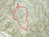
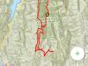
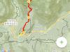
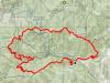
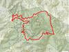
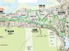
9/22/2018 (토) Gap/Ridge Large Loop
Views 22788 Comment 11
?
Larger Font
Smaller Font
Up
Down
Update Log Go comment
Print Shortcut
PrevPrev Article
NextNext Article
?
Larger Font
Smaller Font
Up
Down
Update Log Go comment
Print Shortcut
PrevPrev Article
NextNext Article
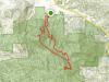
| 산행지 | Gap/Ridge Large Loop |
|---|---|
| 난이도 | Moderate (중간) |
| 예상거리 (mi) | 13 mi |
| 고도변화 (ft) | 2300 ft |
| 예상 산행시간 (hr) | 6 시간 |
| 모이는 시간 및 장소 | Saratoga Gap 주차장 ( 37.258327, -122.121298 ) @8:30 AM |
| 산행 준비물 | 점심 및 간식, 충분한 양의 물 |
아리송님이 올리신 것을 참고했습니다.
여기 파킹랏이 MTB 바이커나 하이커들로 일찍 찰수 있습니다. 해서 산행시작 시간을 8시30분 으로 정했습니다.
찾아 오는길 : https://goo.gl/maps/9vdhgpJXN9t
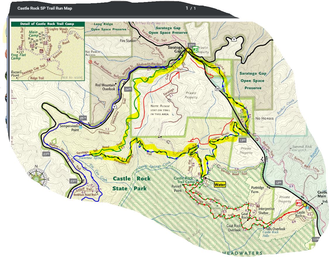
Favorite Run #2: Gap/Ridge Large Loop (13.0 mi, ~2300 feet elevation gain)
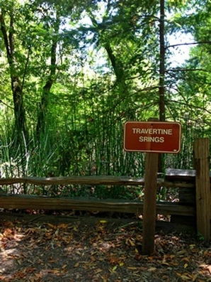
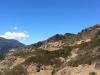
This loop is a challenging but beautiful run with some great climbing and excellent views. It incorporates the highlights of the previous run with a trip to Travertine Springs and a steady, moderate climb up Saratoga Toll Road. For this route we strongly recommend that you bring a trail map or download the GPX track to your GPS device, since some of the turns are confusing. This run starts at the Saratoga Gap parking lot. To start the run, head south on the Skyline trail, which begins at the southeast side of the parking lot (the side of the parking lot opposite from Hwy 9). Route Details:
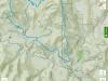
https://www.alltrails.com/explore/map/skyline--240 (아마도 링크를 클릭하면 안보이실 겁니다. 아래 맵이...) 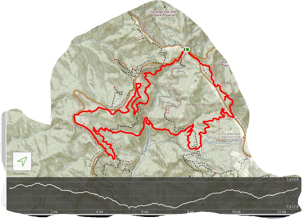 |
-
 1번으로 참가합니다.
 -
?
반갑습니다
추석이 다가오니 송편을 준비해야겠어요.^^ -
아, 맞아요. 추석이 다가 오네요.
송편 산행 기대 됩니다. ^^ -
?
Journey/미미 참가합니다.
-
?
참석합니다. 송편 먹으러~
-
?
입하나 덜어도 되는데요...
ㅎㅎ장난이예요맛난 배까지 준비해야겠네요~~ -
 송편 남는 거 그 다음 날 산행에 갖고 오실거죠?ㅎㅋ
 -
?
네
-
THX
-
?
창공님,미미 져니님, 두물차님,부엉이 솔개님, 저 동행
내일 뵙겠습니다. -
?
솔개& 부엉이 참가합니다.
26일 걷고도 아직 미련이 남는가 봅니다.
-
Read More
12월29일 (토) Homestead-Blue Ridge
찿아오는길: 블루 리지 트레일헤드 22095 CA-128, Winters, CA 95694 https://maps.app.goo.gl/tGQMv -
Read MoreNo Image
12월 29일 토요산행 Angel Island SP
2018년의 마지막 산행은 Tiburon 에서 ferry 를 타고 들어가 Angel Island state park 에서 보내면 어떨까 합니다. 10:00 에 출발하는 ferry 를 타고 마지막 3:30... - Read More
-
Read More
12월22일(토) Ralston peak
찿아 오는길 : 랠스턴 트레일헤드 https://maps.app.goo.gl/Agghd -
Read More
12/15(토) Rancho Canada Del Oro OP (Serpentine Loop...
창꽃님이 공지한 산행지가 너무 먼 곳이라 다정기 산행지로 가까운 곳으로 하나 더 올립니다. 제가 송년 산행에서 그날 산행이 올해 마지막 산행이라고 공언하였... -
Read More
(취소) 12/15/18 (토) Mount St. Helena - Napa County
찾아 오는 길 산행 출발 시간은 아침 8:30 입니다. (파킹 공간이 제한 되어있다고 합니다. 조금 더 일찍 시작 하는 제일 큰 이유입니다. 그리고 조금이라도 일찍 ... -
Read More
12/08(토) 송년산행 Huddart County Park
이번주 토요 산행은 2018 송년을 기념하고 새 회원님들 환영하는 자리로 마련하겠습니다. 3시간 산행 후에 12시까지 훗다트 공원 주차장으로 돌아와서 피크닉 장... -
Read More
토요산행, 12/01/2018, Tarwater Creek
벌써 한 해의 마지막 달인 12월이 다가 오네요. 이 코스는 제가 무척 좋아하는 루트입니다. 함께 하셔서 레드우드의 진수를 같이 맛 보시죠. [변경 내용] 이번 산... -
Read MoreNo Image
11/23 (금) Echo Peak, Lake Tahoe
트레일 맵은 아래 URL을 참조 바랍니다. https://www.alltrails.com/explore/trail/us/california/tamarack-aloha-loop 후반 두시간은 야간 산행이 될 껄로 예상... -
Read More
11월24일<토> Mt. Diablo (Eagle Peak to Mt. Di...
MAP URL: Regency Drive 찾아오는 약도 집결지 사진 (주택가 막다른 길): 산행루트: GEORGE CARDINET BACK CREEK Trail --> Bruce Lee Road --> Eagle Peak Trail... -
Read More
11/17(토) Mt. Madonna County Park
원래 연간 계획에 나와 있던 Pinnacle National Park로의 산행 대신에 2015년 9월을 마지막으로 방문길이 끝겼던 Mt. Madonna를 오래간만에 방문해 보겠습니다. ... -
Read More

11월10일(토) Little Basin SP (Boulder Creek, CA)
11/9일 토요일에 특별 1일 산행을 Little Basin State Park에서 해 보려고 합니다. Redwood Tree가 울창한 Little Basin에서 토요일 당일 산행을 원하시는 분들은... -
Read More
11월10일(토)Anthony Chabot Regional Park
찾아오시는길 https://goo.gl/maps/JQexbY1tYh32 @: 2차 집결지 Trail Map: Horseshoe (0.08) -- Grass Valley (0.96) -- Redtail (1.29) -- Cottontail (0.55) -... -
Read More
11/3(토) Pleasanton Regional Park 정기 산행
9:00 AM 에 시작하겠습니다 오시는길 https://goo.gl/maps/YB7QxRjTCHP2 GPX File: Pleasanton_regional_park.gpx -
Read More
10월27일 토요일 Lake Tahoe
이번 산행은 앞산님대신 산행공지 올립니다 산행 가이드도 앞산님이 해주십니다. "찾아 오는 길" 정보를 올립니다. 구글 링크 입니다. 38.81029, -120.23954 (이 ...