2016.03.18 11:43
Milpitas지역 추천 산행지.(Ed Levin County Park)

여기도 산악회에서는 한번도 안가본데 같은데.
Ed Levin County Park
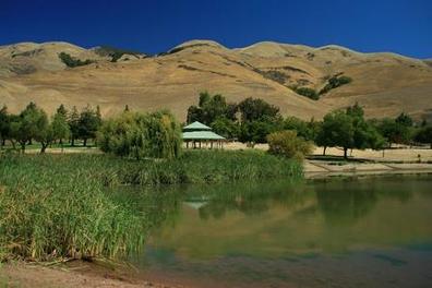
Ed Levin County Park is a unique multiple activity park located in the hills just east of Milpitas. Even though the park is located less than 20 minutes from an urban area, it offers miles of challenging trails as well as many other activities such as picnicking, fishing, and even has an off-leash dog park for Fido. In addition, the park provides several launch sites for hang gliders and paragliders.
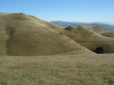
The trails in Ed Levin are mainly fire roads that range from moderate to very steep. The elevation in the park varies from around 500' near the lake to over 2500' near the summit of Monument Peak. Because of the elevation gain, Ed Levin Park is a great place for some hill training, only minutes from the urban area. Your efforts are rewarded with great views of the Bay Area. And, the trails connect to Mission Peak Regional Preserve, so very long and challenging runs or hikes are possible by linking the two parks.
The weather in Ed Levin County Park is typically mild in the winter and hot and dry in the summer. There is very little shade in the park, so we recommend bringing plenty of water and wearing sunscreen if you attempt the trails in the summer!
All of the runs on this page start from the trailhead near the dog park by Sandy Wool Lake.
The Dirt:
Extras:
The trails in Ed Levin are mainly fire roads that range from moderate to very steep. The elevation in the park varies from around 500' near the lake to over 2500' near the summit of Monument Peak. Because of the elevation gain, Ed Levin Park is a great place for some hill training, only minutes from the urban area. Your efforts are rewarded with great views of the Bay Area. And, the trails connect to Mission Peak Regional Preserve, so very long and challenging runs or hikes are possible by linking the two parks.
The weather in Ed Levin County Park is typically mild in the winter and hot and dry in the summer. There is very little shade in the park, so we recommend bringing plenty of water and wearing sunscreen if you attempt the trails in the summer!
All of the runs on this page start from the trailhead near the dog park by Sandy Wool Lake.
The Dirt:
- Click here to download a printable map of the Favorite Runs below!
- Click here for the official park site with trail map.
- Click here for driving directions to the trailhead near Sandy Wool Lake.
Extras:
- The only drinking water available in the park is located near the trailhead by the dog park. There is no drinking water available along the trails!
- There is a fee to enter the park.
- If you are interested in learning more about paragliding or hang gliding in the park, visit the Wings of Rogallo site.
Favorite Run #1: Monument Peak Lollypop (9.0 mi, ~2500 feet elevation gain)
This run starts at the trailhead near the dog park and takes you all of the way up to the summit of Monument Peak. The views of the Bay Area from the trails are spectacular, so bring your camera! The trails are mainly fire roads, and they can be hot, sunny, and dry in the summer so bring plenty of water! To get to the trailhead, drive past Sandy Wool Lake and follow signs to the dog park. Park in the paved lot near the dog park and look for the Tularcitos Trailhead. GPX Track Printable Trail Map Driving Directions |
Route Details:
 View from the Monument Peak Trail
- 0.0 mi: Start up the Tularcitos Trail toward Monument Peak.
- 0.2 mi: Turn left through the gate to get on the Agua Caliente Trail. You will pass through several gates and cross a few roads on your way to the peak.
- 1.6 mi: Just after crossing Monument Peak Road turn right at the cattle drinking trough onto Monument Peak Trail. You will climb steeply for a bit. If you start descending you are going the wrong way! Continue on Monument Peak Trail all of the way up to the ridge.
- 3.7 mi: At the ridge, the trail turns to a gravel road. To get to the actual summit, head past the radio tower and turn right on the next gravel road. Follow this road for a quarter-mile to the summit.
- 4.1 mi: At Monument Peak summit! After enjoying the view, retrace your route back to the intersection. But instead of heading down Monument Peak Trail, follow the signs to Agua Caliente Trail.
- 4.4 mi: Get onto Agua Caliente Trail. Get ready for some steep downhills and amazing views! You will follow the Agua Caliente Trail most of the way back to the trailhead.
- 7.5 mi: Confusing intersection! Cross Monument Peak Road and make sure to stay on Agua Caliente Trail!
- 8.8 mi: Agua Caliente Trail ends at Tularcitos Trail. Head through the gate and back to your car.
- 9.0 mi: Back at your car!!
Favorite Run #2: Ed Levin to Mission Peak (12.5 mi, ~2700 feet elevation gain)
This run combines the hill climb of Favorite Run #1 with an out-and-back to Mission Peak. The trail from Monument Peak to Mission Peak is almost other-worldly, rolling through the backside of the ridge. Approaching Mission Peak from this direction gives you a unique and rarely seen perspective of the peak. Note that this route has a LOT of climbing and almost no shade, so please bring plenty of water on a hot day! To get to the trailhead, drive past Sandy Wool Lake and follow signs to the dog park. Park in the paved lot near the dog park and look for the Tularcitos Trailhead. GPX Track Printable Trail Map Driving Directions |
Route Details:
 The trail along the backside of the ridge
- 0.0 mi: Start up the Tularcitos Trail toward Monument Peak.
- 0.2 mi: Turn left through the gate to get on the Agua Caliente Trail. You will go through several gates and cross a few roads on the way to the peak.
- 1.6 mi: Just after crossing Monument Peak Road turn right at the cattle drinking trough onto Monument Peak Trail. You will climb steeply for a bit. If you start descending you are going the wrong way! Continue on Monument Peak Trail all of the way up to the ridge.
- 3.7 mi: At the ridge, the trail turns to a gravel road. Continue straight on the gravel road past the radio tower and onto the Bay Area Ridge Trail toward Mission Peak. The trail gently rolls along the backside of the ridge all of the way to the peak.
- 5.8 mi: At Mission Peak summit! Enjoy the view, then retrace your steps back to the radio tower near Monument Peak.
- 7.9 mi: Back at the radio tower near Monument Peak. Instead of heading back down Monument Peak Trail, follow the signs to get onto Agua Caliente Trail. Get ready for some steep downhills and amazing views! You will follow the Agua Caliente Trail most of the way back to the trailhead.
- 11.0 mi: Confusing intersection! Cross Monument Peak Road and make sure to stay on Agua Caliente Trail!
- 12.3 mi: Agua Caliente Trail ends at Tularcitos Trail. Head through the gate and back to your car.
- 12.5 mi: Back at your car!!


- Read More
-
Read MoreNo Image
책 소개합니다 - Off the Wall: Death in Yosemite
"흥미있는" 책 하나 소개하겠습니다. 제목은 "Off the Wall: Death in Yosemite" 1851년 부터 2012년 까지 우리가 즐겨 찾는 요세미티 국립공원에서 기록된 사고... -
Read More
정 떼면서 살기
안녕하세요. 제가 풍란을 좋아합니다. 주로 섬의 바위에 붙어 불어 오는 바람에 몸을 낮게 움추리면서 바위 위로 흐르는 적은 양의 물로 살아가는 근데 화려한 양... -
Read MoreNo Image
좋은글(펌)
이 글을 읽고 저 부터 반성하게 하네요 ♡잔인하게도 ~ 인간은 백번 잘해줘도 한번의 실수를 기억한답니다. ♡사람의 마음은 간사해서 수많은 좋았던 기억보다 단 ... -
Read MoreNo Image
'정대위' 최종결론
오늘(토) 12시. 쟈니워커님. 선비님. 베어님. 나그네. 그리고 참관인으로 웹매스터 지다님이 참석하신 가운데 많은 이야기를 나누었으며, 베이산악회가 처한 상황... -
Read MoreNo Image
하프문 베이에서 라면 끓어 먹기
하프문 베이에 가면, 가끔씩 저녁 놀을 보면서 두고 온 고향을 그리워 하기 좋은 곳 입니다. 몸에는 안 좋지만 라면을 끓어 먹으면서 파도랑 새소리, 주둥이 긴 ... -
Read MoreNo Image
Shoreline trail in Mountain view
아 산에 갔어야 했는데.. 오늘 못갔네요. 자전거도 못타고.. 이제 하프문 베이에 가든지 아니면 shoreline에나 가야 겠습니다. 혹시 안가보신 분 계시면 한번 가... -
Read MoreNo Image
침낭보온법
1. 따뜻한 침낭 예상되는 기온보다 5도에서 10도 정도 더 낮은 내한온도를 가진 침낭을 사십시오. 다른분들이 내한온도 영하 6도의 침낭을 꾸릴 때 영하 12도 정... -
Read More

배낭사이즈 선택을 위한 토르소측정법
우리 베이산악회의 모든 게시판이 오로지 산에 관한 유익한 정보, 즉, 하이킹, 트레일과 백패킹 정보들로만 가득해지기를 기대합니다. 이번엔 백패킹을 위해 새로... -
Read MoreNo Image
개인간의 카톡내용을 공개할 수도 있군요
Thursday, March 10, 2016 아싸님 나그넵니다 어제 자연님이 올린 글을 본 후 전화와 카톡으로 정상화 대책위원회 회의를 가졌습니다 회원간의 화합을 저해하고 ... -
Read MoreNo Image
진달래님?
제가 게시판 들어와 본지 오래 되어서 며칠 전 지나간 글들을 훑다가, 어느 횐님이 진달래님인지 (?) 비밀번호를 잊어버려서 못들어온다고 한 댓글을 본 기억이 ... -
Read More
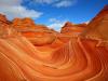
The Wave!! 소개
The Wave, Marble Canyon, Arizona 얼마 전에 다녀온 The Wave라는 곳을 소개 합니다. 송암, 소연님로부터 웨이브라는 곳에 대해 듣고 집으로 돌아와 검색해 보곤... -
Read MoreNo Image
3/26(토) 산행지 추천 받습니다.
현재 운영진 산행계획방이 역할을 제대로 못하는 관계로 담주 로컬 산행공지 하실분들은 여기에 안을 올려주심 좋겠습니다. 부정기니까 두 군데 정도 올라와도 좋... -
Read MoreNo Image
산행정보방
산행정보방은 산악회에서 다녀온 산행지에 대한 정보위주로 저장히는곳이고 현재 정회원님들만 참조할수 있는걸로 알고 있습니다. 오늘 제가 올린곳은 산악회에서... -
Read MoreNo Image
아리송님께
좋은 산행정보 감사합니다. 그런데 이런 유익한 정보는. 자유게시판이 아닌 산행일정에 산행정보에 들어가 있어야 하지.않을까요.? 1시간 제약때문에 옮겨지지 않...