오는 10월 30일부터 11월 1일까지 Mt Diablo 에서 아래와 같이 산행과 캠핑을 합니다.
10월 30일 (금): 달맞이 야간산행 -- Boundary 캠프에서 Mt Diablo Summit 까지 왕복, 6+ 마일.
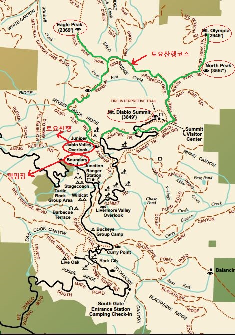
10월 31일 (토): Diablo Three Peaks 주간산행 -- Diablo Valley Overlook에서 0900 출발, Eagle Peak (2369 ft), North Peak (3557 ft), 그리고
Mt Olympia (2946 ft) 의 정상들을 경유해서 돌아옴, 10+ 마일.
11월 1일 (일): Rock City 주변 주간산행 -- Rock City 주변 트레일에서 5-6 마일 산행 + Rock City 암벽 놀이
(횐님들의 요청이 계시면 일요산행지를 변경할 수도 있습니다.)
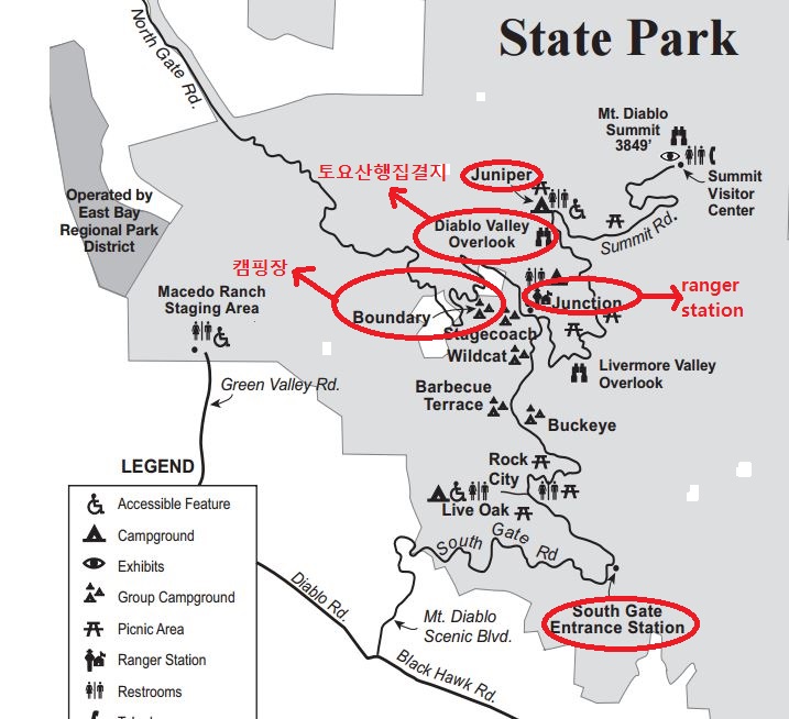
캠핑: Boundary Campground Group Site (인원 max 20 명, 차량 max 7 대), 금/토 2 nights
*필독 사항
(1) Mt Diablo는 0800--일몰시간 동안만 gate 를 open 합니다. 따라서 10월 30일 (금) 야간산행을 원하시는 횐님들은 캠핑을 하셔야만 합니다.
(2) 10월 30일 (금) 에 캠핑하실 분들은 반드시 gate 를 닫는 일몰시간 (오후 6시) 전에 공원안으로 들어가셔야 합니다.
(3) 캠핑하시는 분들은 공원 Entrance Fee 를 따로 내실 필요가 없습니다. 공원에 들어가실 때 필요한 정보는 개별 통보해 드리겠습니다.
(4) 캠핑없이 토요산행을 원하시는 분들은 0900까지 집결지인 Diablo Valley Overlook 주차장 (Juniper Campground 입구) 으로 오십시오.
(5) 캠핑없이 일요산행을 원하시는 분들은 0900까지 Boundary Campground Group Site 로 오시면 되겠습니다.
(일요산행지가 변경되면 공지 또는 개별 연락 드리도록 하겠습니다.)
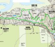
참고 지도 (녹색선: 토요산행 코스)
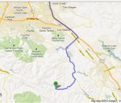
참고 약도
Driving Instructions
Closest GPS address (North Gate): 1250 North Gate Rd., Walnut Creek, 94598
Closest Physical Address (South Gate): 2626 Mount Diablo Scenic Blvd., Danville 94506
(Don’t use: 96 Mitchell Canyon Rd., Clayton 94517 to drive to the summit as there is no road access from this park entrance)
To reach Mt. Diablo State Park and the summit from north of Walnut Creek, Contra Costa County,
follow Interstate 680 south and exit Treat Blvd and follow Treat Blvd east to Oak Grove Road. Turn south on Oak Grove Road. Continue on Oak Grove Road after crossing Ygnacio Valley Road continuing to North Gate Road on the left. Use North Gate Road to enter the park. To reach the summit, turn left on Summit Road at the Junction Ranger office.
To reach Mt. Diablo State Park and the summit from the south,
follow Interstate 680 north from the Pleasanton / Dublin area. Exit on Diablo Blvd in Danville traveling to the east. Diablo Road makes several turns enrouth to Mt. Diablo Scenic Drive. Continue on Diablo Road past a firestation on the right until you reach Mt. Diablo Scenic Drive. Turn left and follow this road into the park.. To reach the summit, turn right on Summit Road at the Junction Ranger office.
To reach Mt. Diablo State Park and the summit from the west,
follow Route 24 through the Coldecott Tunnel toward Walnut Creek. Follow Route 24 and exit on Ygnacio Valley Road. Follow Ygnacio Valley Road east and turn right on Walnut Avenue (not Walnut Blvd). At the end of Walnut Avenue, turn right on Oak Grove Road briefly and then turn left on North Gate Road. Use North Gate Road to enter the park. To reach the summit, turn left on Summit Road at the Junction Ranger office.
 Sanborn County Park (12/12/15)