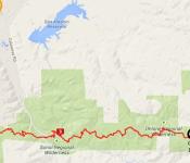
(7) Tahoe Meadows(8740') to Spooner Summit (7150')
총 23.1 마일. Add Christopher's Loop trail which is an extra 1.2 miles round trip.
[계절]
6월 중순에서 10월말
The section between Twin Lakes and Snow Valley Peak may hold snow well into July.
[물]
물을 구하기 힘든 구간이다.
타호 메도우즈 트레일에서 0.7 마일쯤에 일년내내 물을 구할수 있는 Ophir Creek 이 있다.
타호 메도우즈 트레일에서 3 마일쯤에 2개의 계절성 샘물이 있다.
타호 메도우즈 트레일에서 9 마일쯤에 작은 2개의 Twin Lakes 이 있으나 여름철이 끝나갈 시기에는 물이 많이 줄어들어 더럽다.
트레일 다 끝나가는곳에 Spooner Lake 이 있다.
[캠핑]
Tahoe Meadows 에서 남쪽으로 트레일의 절반쯤에 있는 Tunnel Creek 산등성이까지는
National Forest 땅이라 아무데나 캠핑이 가능하다.
그러나 Lake Tahoe NEVADA 주립공원에 들어서면 캠핑은 반듯이 2 군데의 캠프장 에서만 해야한다.
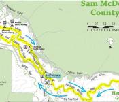
Lake Tahoe Nevada State Park at Sand Harbor : 775-831-0494 For Camping Information : No reservation required for Camping
Marlette Peak Camp Ground (13 miles south of Tahoe Meadows) Marlette Peak 에 있다.
North Canyon Camp Ground (Spooner 에서 시작하면 5.2 miles north of Spooner then follow signed connector trail 1.4 miles.
Tahoe Meadows 에서 시작하면 At a minor saddle, just before you reach Snow Valley peak take a dirt road 1.2 Mile steeply down North Canyon Road 를 따라 감. 길의 서쪽으로 아스팬 그로브가 있는곳에 작은 개천이 있다.
Twin Lakes 에서는 캠핑할수 없다.
[트레일]
하이커, 말이 다 허용되고 자전거는 일부분만 된다.
트레일이 길고 많이 올라가야/내려가야 하기때문에 Strenuous,
꺼꾸로 가면 Spooner Summit 에서 Snow Valley Peak으로 1800'를 올라야하기 때문에 더욱 더 힘들다.
대부분의 트레일이 바람과 햇볕에 노출되 있다.
Christopher' Loop (Herlan Peak) spur trail offers especially remarkable vistas.
Christopher's Loop goes out to the the edge of steep granite drop away, dramatically over-looking Sand Harbor about 3000 feet below. It's one of the most beautiful settings. Christopher's Loop trail which is an extra 1.2 miles round trip.
.
Side Trip - Marlette Lake (Wildflowers display is one of the best to be found anywhere)
Aspen Groves at Snow Valley, Marlette Lake and Spooner Lake
Aspen Groves at Noth Canyon Road is Spectacular in the fall.
트레일을 처음부터 끝까지 안가고 Tunnel Creek Rd 로 중간에 빠져나올 수도 있다.
Highlights:
▲ Christopher’s Loop (most photographed spot on TRT) ▲ Marlette Lake view
Marlette Lakes, Twin Lakes, Tahoe Basin and Washoe Valley. Snow Valley Peak(9214')![]()
Trailheads
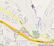
- Spooner Summit North, is on the north side of Hwy. 50 at Spooner Summit. Limited paved parking, interpretive signing.
- Tahoe Meadows, is on Hwy. 431, 1 mi. west of US 395 and 1 mile west of the Mt. Rose Summit Welcome Plaza. Vault toilets, paved parking with room for horse trailers. Tahoe Meadows Interpretive Loop Trail starts and ends here. Closed due to snow in the winter
- Alternate access - Tunnel Creek Rd. climbs steeply 3 miles from Hwy. 28( Hwy. shoulder parking) to intersect the TRT 9.2 mi. north to Tahoe Meadows and 13.1 miles south to Spooner.