1. 각자 집에서 출발점까지 왔다가
다시돌아감.
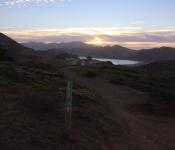
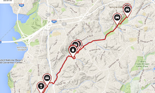
2.출발 점 8:30 AM Rudgear staging area ( Alamo//Danvile 중간)
3. 준비물 : 자전차
물
행동식 or 돈 or Credit Card
windbreaker, arm warmer, leg warmer, 장갑, mask
구급약/ 썬블락 로션
연락처 : (707)480-8867 kenn
4.참고
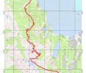
Iron Horse Regional Trail Facts
Iron Horse Regional Trail Description
 View Trail Map
The area surrounding the Iron Horse Regional Trail has an important history as part of the San Ramon Valley's agricultural and ranching past. Today, the Iron Horse Trail connects two counties and twelve cities. It runs through quiet residential neighborhoods, lively business and commercial districts and shady greenbelts. This popular and extensively used trail roughly follows Interstate 680, beginning in the city of Concord on its northern end and passing through Pleasant Hill, Walnut Creek, Alamo, Danville, San Ramon and Dublin before ending at the northeast edge of Pleasanton.
Plans call for the trail to be extended farther south to Stanley Boulevard in Pleasanton, where an existing bike trail leads east to Livermore. On the north end, there are plans to continue the trail to Suisun Bay in Martinez.
At the current northern end, the trail begins just south of State Route 4, near the northeast corner of Buchanan Field Airport in Concord. The trail nears the Pleasant Hill BART station at about mile 5. A rest stop across the street from the BART parking lot features picnic tables, a drinking fountain and benches. The northernmost part of the trail, as well as the proposed area around Suisun Bay, follows a marshy area, which is a haven for ducks and geese.
As you head south, the area becomes increasingly more urban, especially near downtown Walnut Creek. The Walnut Creek BART station is about a half mile off the trail here. Bicycle and pedestrian overpasses span Treat Boulevard near the Pleasant Hill BART and Ygnacio Valley Road in a congested section of Walnut Creek. South of Walnut Creek, the trail passes under I-680 at Rudgear Road to the west side of the freeway. A staging area here features parking, a drinking fountain, benches and tables.
From this point, the trail meanders through residential areas, crossing streets numerous times—though traffic is typically low—and offers easy access to restaurants and shopping. Much of the trail in this section includes a dirt running path adjacent to the asphalt bike trail.
In Danville, the trail passes directly behind the commercial downtown area. Nearby at the corner of Railroad and Prospect avenues is the old Southern Pacific Depot, which is the only original depot remaining on the line. Just past the depot is a pleasant area, featuring restaurants with outdoor seating overlooking the trail.
Picking up the trail again, you cross under I-680 to the east side and traverse Bishop Ranch Business Park, a commercial section that parallels the trail for about 2 miles. Next you reach the San Ramon Golf Club. The trail bisects the golf course, with chain-link fencing providing protection from errant golf balls. As the trail slices through Dublin, the environment is urban once more.
You next pass the Dublin/Pleasanton BART station and cross under I-580 before heading through some of Dublin and Pleasanton's dense housing and business development. The trail briefly leaves the former rail corridor at Arroyo Mocho and Santa Rita Road but picks it up again south of Stoneridge Drive. The final stretch runs in a wide corridor between fenced-in backyards before ending at Valley Avenue.
Parking and Trail Access
To reach the northern trailhead, take State Route 4 westbound to Arnold Industrial Way. Turn left onto Arnold Industrial Place and left again on Solano Way. Follow Solano Way and go under SR 4. Turn right onto Marsh Drive. The signed trailhead is on your left. Street parking is limited.
To reach the trailhead at the Dublin/Pleasanton BART station, exit Interstate 580 at Hopyard Road. Turn right on Hopyard Road and proceed for 0.3 mile. Turn right on Dublin Boulevard and go 0.5 mile. Turn right on Demarcus Boulevard, which leads to the station. The signed trailhead is at the north end of the parking lot.